

Just having a fair dinkum go at life 🌴 🇦🇺 Doing lots of cool stuff at @soaratlas, Detail and Marlin (🦈)
San Francisco, CA
Joined July 2017
- Tweets4K
- Following1.1K
- Followers1.2K
- Likes3.9K




El Nino-ing...

A desert so full of flowers it's visible from space? 🌸
Yes! Chile's Atacama Region, one of the driest places on Earth, occasionally turns into sea of wildflowers, known as the Desierto Florido.
Explore the map:🗺 tinyurl.com/354c7pcu
#chile #atacama #bloom #flower
4
137

Absolutely horrific 🥺 RiP to all on board the plane soaratlas.com/maps/america-u…

1
3
449
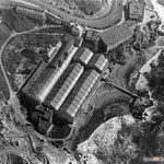
Meet San Francisco's famous Sutro Baths 🛁📸via aerial imagery from @sfgov on @SoarAtlas direct link to map in 1948 - tinyurl.com/2kzjkx67 Been going to Lands End for years. Never knew it looked like this before it burnt down in 1966. All that remains is basically a lake 😥


Is Iran shifting more of its trade towards the Caspian Sea?
Shipping activity in the Caspian reportedly rose from 127 Russian and Iranian-flagged vessels in February to 211 in March 2026.
With the U.S. naval blockade putting pressure on Iran’s southern trade routes, Tehran may be increasingly relying on its northern corridor to move essential goods and maintain trade with Russia.
Satellite imagery of Nowshahr Port and Bandar Anzali could offer clues to how these routes are being used as the war continues.
Nowshahr Port: tinyurl.com/yhykyszs
Bandar Anzali: tinyurl.com/yc4acsrc
What do you think?
Some of these data centres are churning up the landscape like bad growing weed! soaratlas.com/maps/142936 This one in Texas is almost 6km2! 😳
It would be prudent to do analysis to see how much of the worlds surface in km2 has been taken up by data centres vs solar panels etc

Incredible use of the 'Stoaries' feature on @SoarAtlas

🎬 - Zaporizhzhia Nuclear Power Plant Structure -
Discover the story behind the ZNPP layout map now on @SoarAtlas, and use satellite imagery to understand its structure and functions. I hope you find this useful.
You can find the map at this link:
- 🗺️soaratlas.com/draw/3346


5
218
A cookie for the first person and that recognises this fabled city captured at night time from satellite, viewed in @SoarAtlas new 3D animation fly through capture mode 🎥 ⛰️
So Turkiye is building a nuclear power plant. Hope theres lots of LEU and no HEU 🕊️☢️
From an empty coastline to one of Türkiye's largest infrastructure projects.
This timelapse shows the Akkuyu Nuclear Power Plant from 2017 to 2026. When done, it will supply around 10% of Türkiye’s power needs.
Explore and Compare: tinyurl.com/4cwe4hv7
#Turkey #Powerplant
1
189
👋 CC: @mhmiranusa @BabakTaghvaee1 @AnalyticaCamil1 @Osint613 @Shayan86 @hadinik @IranObserver0 @RedIntelPanda @MenchOsint @ME_Observer_ @vcdgf555 @Arabosint @EGYOSINT
We’re seeing more and more satellite timelapses shared with creators’ own branding, and we love it!!
Try it here: 👉 soaratlas.com/satellites
Your work should be recognisably yours. Upload your logo or image and Soar handles the rest for you.
Try the watermark feature on your next GIF timelapse.
4
147
9th Sept: Sentinel satellite imagery shows Iranian Navy speedboats departing the vicinity of a tanker. Interestingly, the tanker, as evidenced by its wake, appears to be continuing on its course out of the SoH, while the Iranian vessels head back into Iranian territorial waters.
1
3
167
😱
🔥🌏Just to put the sheer SCALE of this attack into perspective...
The smoke stretched more than 100 km across the Saudi desert and was visible from space even when zoomed all the way out to a global view of Earth.
See for yourself: tinyurl.com/2v4de47t
Nom nom 😋
Calling all investigators
We just dropped new tools to help you analyse imagery faster, including:
🛰️ Countdowns to the next satellite capture
🎥 Watermark timelapses to make them yours
Try it now:👉 soaratlas.com
#OSINT #Journalism #RemoteSensing #SatelliteImagery
Jeepers! Krakatoa volcano goes kaboom CC: @SoarAtlas direct link for satellite imagery updated every 3 hours. soaratlas.com/maps/global-wo…

The ocean is boiling! Surprised we haven't seen any hurricanes in the western Atlantic yet. 🔥 @extremetemps @wammezz @sergioajv1 @weatherchannel @WeatherProf
Direct link for tracking daily world water temperatures here via satellite: tinyurl.com/4e3wkk23

🌪🌪🌪THREE hurricanes were visible simultaneously across the Pacific on Sept 2nd.
Explore and Compare:👉 tinyurl.com/2j4yyebt
Hurricanes Lowell, Karina and Marie were seen together. A fourth, Tropical Depression Edouard, is also visible over the Gulf Coast of the US.
Sacrebleu! 🇫🇷
Go back in time to France in 1950! ⏱
This massive high-res map lets you discover what France looked like from 1950, comparing it to today with the slider over any area.
Explore and Compare:📷 tinyurl.com/mr3hjpxu
#France #History #VintageMaps
2
144
Things are getting a bit cray cray with all these new geographic names...
Lake America or Lake Ontario? 👀
Soar uses many basemaps, including OpenStreetMap, which is shaped by a global community of contributors.
Google’s change to “Lake America” may be visible in some places, but for now, Lake Ontario is still on Soar: 👉 tinyurl.com/2uk2m2wp
1
146
@wammezz love to get your thoughts on this? Any information on the currents in the region?
🚨🔍Satellite imagery shows a MASSIVE oil spill spreading through the Strait of Hormuz following the bombing of oil tankers. Could the slick reach the coastline of Dubai?
Explore and Compare: tinyurl.com/4z8caxry
#UAE #Dubai #Iran
2
163