

Weather team providing live weather coverage with degreed meteorologists & storm chasers focused in Kentucky. Business inquiries:[email protected]
Joined April 2025
- Tweets7.7K
- Following235
- Followers1.3K
- Likes2.4K


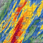


Freeze warning tonight! Growing signal for a storm system next week. Snow potential in Kentucky? Covering the latest data! zmcweather.com/functions/ogB…

Quite a *Frosty* start this morning as expected across North and South Central KY with temperatures dropping hovered near Freezing and mid-30°s.
TODAY, an abundance that blue sky but staying cool only in the 50°s as dense surface High Pressure keeps us Dry and Sunny.

Zero Meter Chasers retweeted

Happy Saturday everyone! Temperatures overnight got into the middle and lower 30s as many experienced some type of frost/freeze this morning!
Forecast looks absolutely PERFECT today with highs in the mid 50s and light winds during the day!
This will setup our first FREEZE warning as we get into Sunday morning. Widespread temperatures below freezing look likely as we wake up on Sunday morning!
Big game in Knoxville, Tennessee tonight that I KNOW I am watching! Enjoy the day, GO CATS!😼 #KYwx

ON THIS DATE IN 2005:
One of the more memorable nocturnal fall Severe Weather events that struck the Lower OH Valley was the Evansville F3. It was a warm and balmy early November Saturday evening as a compact Negative Tilted Trough out of the Upper Midwest had a fast impulse (Shortwave) exiting out of the mid levels of the Jet Stream. Wind energy was coupled with a very warm airmass with Dewpoints in the 60°s.
As you see, the radar was showing a severe line of Storms, semi discrete West of the Wabash and along the Ohio River moving East around midnight. Couple hours later, storms choked off another and became more Celluar gaining Tornadic Characteristics.
One Cell gained all the attention as it dropped a Tornado in Henderson at Ellis Park race track, jumped over the River and dropped back down East of Evansville near Newburgh as it destroyed a Mobile Home park killing over 20. It was F3 intensity
All ingredients came into place for a few hours across Southwest IN/Northwest KY that night. Environment got better after Midnight, it was just a matter of where we would see something drop. A few days later, another Tornado Outbreak occurred in Western KY… more to come in a few days


A chilly evening for HS Football playoff games across the Commonwealth as we'll dip into the 40°s by kickoff. Grab the blankets and heavy coats for this one.

LATER TONIGHT:
A weak, dry, cool front is moving through the region currently. A very brief sprinkle can’t rule out but majority of will stay dry. Skies will clear out as widespread FROST is likely into the Overnight as Temps drop in mid-30°s. Bring in any sensitive plants.


Zero Meter Chasers retweeted
We saw widespread 1-3” of rain from our mid-week system for many in Kentucky!
Forecast looks BEAUTIFUL today for everyone! Colder weather is coming this weekend with a FREEZE potential on Sunday morning! #KYwx

A good soaker of a system we had; especially South Central and far Western KY where drought was increasing. Long range pattern looks Drier as November rolls along.
- Mike

Zero Meter Chasers retweeted
Radar is showing scattered showers still lingering across the I-75 corridor this afternoon! Rain will clear out by late tonight statewide!
We have seen scattered amounts of 1-3" today across the state! This will help with our ongoing drought conditions!
Satellite is showing cloud breaks in western Kentucky behind the cold front. Could lead to a decent sunset where we get clouds fading out!
Beautiful Thursday forecast with COLDER weather expected this weekend! #KYwx


Some mid-level dry air is working in eroding the cloud cover as the heavier showers are well East along I-75 corridor. Some filtered sunshine is possible before sunset.
The * ALL CLEAR* window is increasing to our West as Drier air is rolling in behind the last line of heavier showers that’s approaching I-65 Corridor. West winds are behind the line as we will dry out more later into the Afternoon. Not expecting much severe weather with this last line moving East. Heavy showers and little gusty winds if best.

Model data is still hinting at a swath of 1-3” of rainfall through the day today along the I-65 corridor!
Gusty winds and rain will last through most of the day today! Cooler weather coming behind this! #KYwx

WEDNESDAY 11/4:
Earlier today, I spoke of the chance of seeing this system to our West slow down and some breaks in the showers during the overnight/early morning hours. HiRes data from both CAMS have continued on this solution. If we see breaks in the showers and small window of a couple cloud breaks late morning, a *small window* of Isolated Strong to Severe storm or two can't rule out around Lunch Time. I noted a weak secondary axis of MidLevel Energy 'rounding the base of the Trof choking off the main branch of the Vort Max that could enhance some lift. Dewpoints look to climb into mid-60s which has up trended, along with skinny CAPE values.
SO FAR, the best area of seeing a Storm chance tomorrow should remain South of the Cumberland Parkway into MiddleTN. It all depends on timing. Right now, the line of heaviest showers should slide in somewhere around 9-12PM along the I-65 Corridor. If any slower, a slightly higher/strong storm chance of Gusty winds and small hail main hazard, at the moment.
We'll keep ya updated in the morning how the line progresses.


Zero Meter Chasers retweeted

🪦 to our red headed step child Mesoscale Model, the #NAM
Our boy @SCweather_wx said it’s best:

OVERNIGHT:
The SPC has extended a smidge of the Level 1/5 Marginal Risk to the East in West KY. We still don’t expect any mischief but storms could be strong (some severe) in this area. Gusty Winds remain highest concern. Few warnings could be issued. Line weakens farther East.


Zero Meter Chasers retweeted
Heavy rain starts in western Kentucky late tonight and moves through the state tomorrow!
We could have a strong storm or 2 but widespread severe is not expected!
1-3” of rainfall expected through tomorrow night! #KYwx

Temperatures we mentioned today will make a run at 80° for some and we weren’t kidding. Not shown but the BG Airport has hit 80° within last hour too. Pressure Gradient has increased the winds and fueled these Readings close to 15°+ Above our Average.

LATE TONIGHT/Early Wednesday:
As we have mentioned for last few days, Gustier winds will increase toward Midnight as the Low Pressure slides into the Region. Low Level winds energy will ramp up as surface winds will get up to ~ 40-50mph. NO Severe Weather is expected.


TUESDAY, November 3rd:
A balmy and breezy but Dry Afternoon on tap as are sandwiched between Low Pressure to the West and High Pressure off the Atlantic. A pressure gradient will allow breezy conditions at times but also aid in some very warm temps near 80° as well.
-Mike


Zero Meter Chasers retweeted
Widespread rain will return to Kentucky late on Tuesday night and last through Wednesday!
Latest model data has storms approaching western Kentucky late Tuesday night and advancing throughout the state on Wednesday!
Data has 1-3" of rainfall from this wave in general with localized higher amounts. Severe weather is NOT expected with this round!
Much needed rainfall for many! #KYwx