




Dan Henry retweeted

PLANNING YOUR EVENING: Get ready for a more humid evening tonight as temperatures will likely hover in the mid to upper 70s once the sun goes down. Clouds will linger and we'll only fall into the mid 60s overnight!

Dan Henry retweeted
7 DAY FORECAST: High clouds will be around much of the day on Monday, but we should see some sunshine peek through in spots during the afternoon. A few storms may be possible Tuesday to our west. Better storm chances arrive towards Halloween. Plan costumes accordingly.

Dan Henry retweeted
7 DAY FORECAST: Highs will stay in the 80s most of the week. We have some high clouds that will work in for Sunday and Monday providing "filtered" sunshine. The pattern looks to get more active to end the week, which could bring some rain chances in for Halloween! #TXwx

Dan Henry retweeted

WATCH: Monster cell dumping golf ball size hail right now in North Phoenix. Severe thunderstorm warning expires at 4:30 p.m. and could bring 2.5" hail and 60 mile per hour winds. Live coverage starts at 4P! @FOX10Phoenix

Dan Henry retweeted
7 DAY FORECAST: Cool mornings and nice afternoons will be with us to start the new week. We'll see a slow warmup that takes us back to the mid 80s by the second half of the week. Clouds slowly increase as well, but we'll have plenty of sunny days to enjoy!
Dan Henry retweeted
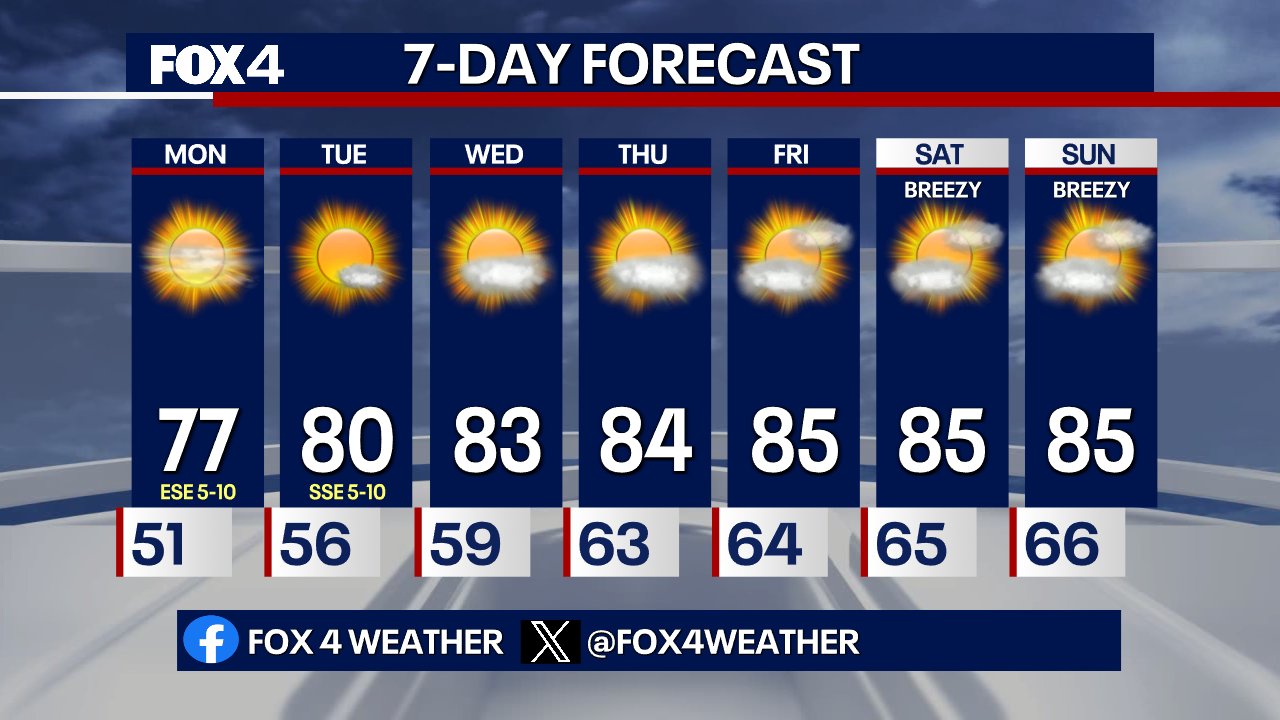
Get ready for another stellar day Monday! We'll have a bit of a chill in place to start the morning, but the afternoon will be beautiful with highs in the upper 70s and plenty of sunshine!

Dan Henry retweeted

Steady warm up on the way. We are rounding out the weekend on a lovely note, and the start of the week brings more of the same, but morning lows return to the mid-60s and afternoon highs return to the mid-80s by the end of the week.

Dan Henry retweeted
It's the final day of the State Fair of Texas, and the weather is perfect! Mostly sunny and 73°! If you haven't had a chance to grab a Fletcher's Corny Dog, or say Howdy to Big Tex, today is your last chance!

Dan Henry retweeted
Hello, Fall! Picture perfect weather in North Texas this weekend, before the 80s make a comeback midweek. Here's a look ahead:

Dan Henry retweeted
7 DAY FORECAST: Chilly mornings and temperature afternoons will be the story of the weekend as winds come down a bit Saturday. We're back in the 70s Sunday with temperatures climbing to the mid 80s by the middle of next week. Enjoy the nice weather!

Dan Henry retweeted
CHILLY MORNING AHEAD: If you're taking the morning jog, you'll need a jacket and sweats! Morning lows will dip into the mid to upper 40s in the Metroplex. Outlying areas could see the lower 40s, and even some upper 30s in river bottoms to the west of DFW. #TXwx

Dan Henry retweeted
PRETTY SUNSET COMING! Check out the view from our Downtown Dallas camera - the high clouds will make for a pretty sunset tonight!

Dan Henry retweeted
FRIDAY NIGHT FORECAST: Heading to watch some North Texas HS Football? Or for a night on the town? Take a jacket, and you might want to go with a hat too - winds will still be whipping a bit and it will be turning chilly! #TXwx

Dan Henry retweeted
7 DAY FORECAST: Cooler air continues to work in overnight, with 50s expected by morning. A few light showers may still be around in the morning, but should clear quickly. Gusty winds stay around up to 40mph with highs in the 60s. Chilly mornings are on the way for the weekend!

Dan Henry retweeted
(10:28PM) As the front has worked through most of North Texas, drier air is starting to eat away at the rain some. Some spotty showers are still around in the Metroplex, with more moderate and steady rain to our southwest. Any rain tonight in DFW should be mainly light. #TXwx
Dan Henry retweeted
WOOHOO! The storms pushed some of the colder air farther south faster and our cold front is now moving through the Metroplex! Temperatures are in the 60s behind it! Get ready for the cool-down and gusty winds! #TXwx

Dan Henry retweeted
(7:14pm) Severe T-Storm warning allowed to expire for Tarrant county, but there are still signs that some 50-60mph gusts could occur from Lake Benbrook to the Chisholm Trail Parkway and into the North Crowley areas. Stay indoors and away from windows! #TXwx

Dan Henry retweeted
(6:33pm) Severe storm with potential for 60mph winds working through Parker county. Highest potential for 60mph wind gusts will be south of I-20 from the south side of Weatherford through Annetta and Aledo and working towards Whiskey Flats/Wheatland. Head indoors! #TXwx

Dan Henry retweeted
⚠️The National Weather Service has issued a Severe Thunderstorm Warning until Oct 15 7:30PM for Tarrant, Johnson, Parker, Hood - Head indoors and away from windows! You can find more info on the Fox Local app! #TXwx