

Emmy Winning Meteorologist for @WIS10. Former @WTNH. Owner @exactweathernow. Follow me Instagram: https://nitter.gq/t.co/EyHxquvH1U Like me on FB: https://nitter.gq/t.co/b6sq3KEDTi
South Carolina, USA
Joined July 2010
- Tweets22.7K
- Following1.1K
- Followers4.2K
- Likes5.9K






Already gusting to 50 MPH here in Milford. This is Woodmont Beach in Milford where two large barges broke loose and washed on shore. Crazy! Look at these waves. #milford #ct #connecticut #barge


Yes, you just felt an Earthquake. Magnitude 4.8 Near Lebanon, New Jersey. Many felt it here in Connecticut.


Final call for the snowstorm tonight/tomorrow
* Snow begins after midnight tonight
* Heaviest 3am-11am
* Ends 2pm-5pm from west to east
* Heaviest snow totals in SE CT
* Lowest snow totals in NW CT
* Wind gusts to 40 MPH
Thanks for the likes and shares! I appreciate it, always

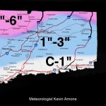
Snow slides in after midnight tonight and will be heaviest overnight into Tue late morning. Snow will taper off during the afternoon. School closures are expected. Most areas see 6-10 inches with a few towns more than that. Exception is far NW CT, 3-6 inches for you.

Good Saturday morning. Fog to start today but it’ll burn off. We’ll see more clouds than sunshine but it will be WARM. Highs in the mid 50s for shore and around 60 inland.
Watching Tuesday for potential for heavy SNOW ❄️


No change to the forecast. Rain moves in Sunday morning and continues throughout the day changing to a wintry mix along the shoreline and eventually snow inland during the afternoon/evening. Precipitation continues to fall overnight as mostly snow. Ends early Monday AM.

Good Wednesday morning! A few slick spots this AM away from the shoreline. Let’s watch for a couple isolated showers today but steadier and heavier rain arrives this evening and continues into tomorrow. Beautiful for Friday! #ctwx #weather #connecticut
Good morning! A few rain showers for your Tuesday but this evening as temps drop, rain showers turn to snow showers and continue into Wednesday morning. Not much in the way of accumulation but could cause some travel issues for the AM commute on Wednesday.
Here comes the BLAST of arctic air. Expect temperatures to drop into the single digits and low teens tonight. Highs tomorrow only in the upper teens! Bitter cold. #Connecticut #weather #ctwx

Thinking of my South Carolina folks today as they’re dealing with some very rough severe weather which include Tornado Warnings. Hope everyone is staying safe.

Good morning! I am not changing a thing from my forecast from yesterday afternoon. Just in case you missed it. Here’s the snowfall accumulation map.


A Severe T-Storm Watch has been issued! Stay with the WIS First Alert Weather Team for the latest. bit.ly/1pFS
