

Official Twitter account of Lafayette County Emergency Management • Not monitored 24/7 • Non-Emergencies call (662) 801-8323
- Tweets2.2K
- Following149
- Followers3.3K
- Likes25







ALT This graphic displays a special weather statement plotted on a map. The statement is in effect until 9:15 AM CDT. The statement includes New Albany MS, Ecru MS and Thaxton MS. The threats associated with this storm are wind gusts up to 50 MPH and half inch sized hail. Seek shelter in a sturdy structure until the storm passes.

ALT This graphic displays a special weather statement plotted on a map. The statement is in effect until 8:45 AM CDT. The statement includes Hickory Flat MS, Potts Camp MS and Myrtle MS. The threats associated with this storm are wind gusts up to 50 MPH and nickel sized hail. Seek shelter in a sturdy structure until the storm passes.

ALT This graphic displays a special weather statement plotted on a map. The statement is in effect until 3:45 PM CDT. The statement includes Oxford MS and Taylor MS. A STRONG THUNDERSTORM WILL IMPACT NORTHWESTERN LAFAYETTE AND NORTHEASTERN PANOLA COUNTIES THROUGH 345 PM CDT. The threats associated with this storm are wind gusts up to 50 MPH and pea sized hail. Seek shelter in a sturdy structure until the storm passes.

ALT This graphic displays a special weather statement plotted on a map. The statement is in effect until 3:30 PM CDT. The statement includes Bruce MS, Pittsboro MS and Paris MS. A STRONG THUNDERSTORM WILL IMPACT SOUTHEASTERN LAFAYETTE and EAST CENTRAL YALOBUSHA AND NORTHWESTERN CALHOUN COUNTIES THROUGH 330 PM CDT. The threats associated with this storm are wind gusts up to 50 MPH and pea sized hail. Seek shelter in a sturdy structure until the storm passes.


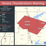
ALT This graphic displays a severe thunderstorm warning plotted on a map. The warning is in effect until 2:15 AM CDT. The warning includes Senatobia MS, Independence MS and Barr MS. This warning is for Northwestern Lafayette County in northwestern Mississippi, Southwestern Marshall County in northwestern Mississippi, Eastern Tate County in northwestern Mississippi and Northeastern Panola County in northwestern Mississippi. The threats associated with this warning are wind gusts up to 60 MPH and quarter sized hail. There are 21,146 people in the warning along with 9 schools and 1 hospital.

ALT This graphic displays Severe Thunderstorm watch number 606 plotted on a map. The watch is in effect until 10:00 PM CDT. The watch includes parts of Alabama, Arkansas, Louisiana and Mississippi. The threats associated with this watch are no tornadoes expected, isolated hail up to quarter size possible and scattered gusts up to 60 mph possible. There are 1,418,277 people in the watch along with 608 schools and 72 hospitals.