Jonathan P. Thompson: https://xitter.cf/t.co/ia5kqWjR7g; author of River of Lost Souls, Behind the Slickrock Curtain, Sagebrush Empire; contributing ed. @highcountrynews;

Western U.S. and beyond
Joined September 2008
The Land Desk retweeted
The San Juan River swells up, spreads destruction The latest round of storms have moved on, but flooding continues By @Land_Desk substack.com/app-link/post?p…
1
1
5
240
The Land Desk retweeted
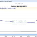
Mr. Brightside's Powell Tracker: San Juan still raging at Bluff: 37,300 CFS Since storms started 9/15: Powell up 809,000 AF Relative to SEP26 Bureau Forecast: Powell up 900,000 AF or 18 years worth of proposed 50,000 AFY Upper Basin fallowing program. Powell about to pass Flaming Gorge's readily available storage. Powell is using USGS instantaneous elevation so is very current. This is new code, so don't trust it :)
4
1
11
1,519
The Land Desk retweeted
𝗨π—₯π—šπ—˜π—‘π—§ π—™π—Ÿπ—’π—’π——π—œπ—‘π—š π—¨π—£π——π—”π—§π—˜: π—”π—‘π—˜π—§π—› 𝗔𝗑𝗗 π— π—’π—‘π—§π—˜π—­π—¨π— π—” 𝗖π—₯π—˜π—˜π—ž, 𝗨𝗧𝗔𝗛 October 25, 2026 | Emergency Flood Response Severe flooding continues to threaten communities in Aneth and Montezuma Creek, Utah, as water levels have risen significantly overnight. Approximately 150 people have been evacuated, and officials warn that water levels could rise by as much as 36 feet by 1 p.m. today, creating dangerous conditions for families and residents. Residents in affected areas are urged to remain alert, follow evacuation instructions and avoid flooded roads, washes and low-lying areas. π—˜π— π—˜π—₯π—šπ—˜π—‘π—–π—¬ 𝗕π—₯π—œπ——π—šπ—˜ π—–π—Ÿπ—’π—¦π—¨π—₯π—˜π—¦ Emergency personnel are shutting down the following bridges due to dangerous flooding conditions: β€’ Highway 160 Bridge β€’ Bridge on Navajo Route 35 from Red Mesa Residents are urged to avoid these routes and follow instructions from emergency personnel. π—˜π— π—˜π—₯π—šπ—˜π—‘π—–π—¬ π—¦π—›π—˜π—Ÿπ—§π—˜π—₯ π—Ÿπ—’π—–π—”π—§π—œπ—’π—‘π—¦ The following locations are being used to shelter displaced residents: β€’ San Juan High School in Blanding, Utah β€” Staffed by the American Red Cross β€’ Aneth Community School π—”π—‘π—˜π—§π—› π—˜π— π—˜π—₯π—šπ—˜π—‘π—–π—¬ π—’π—£π—˜π—₯π—”π—§π—œπ—’π—‘π—¦ π—–π—˜π—‘π—§π—˜π—₯ For emergency information and assistance, contact the Aneth Emergency Operations Center (EOC): 435-651-3754 The safety of our Navajo people remains the highest priority. Residents are encouraged to follow official emergency instructions, check on loved ones when safe and share this information with families in affected areas. The Office of the President remains on-site alongside Navajo Department of Emergency Management, Navajo Police Department, Utah Department of Transportation (UDOT), Utah Navajo Health System, Utah Highway Patrol, and San Juan County Sheriff’s Office. Thank you to all for coordinating response efforts, monitoring flood conditions and working to protect families and communities. Additional updates will be provided as information becomes available.
11
19
681
The Land Desk retweeted
We are getting anither wave of small but pretty violent cells at Arriola. Good remote reporting by @jfleck. Farmington Flood. β€œThe gage at Bloomfield blew out late Thursday night, reading 13,100 cubic feet per second (cfs) before it failed. Downstream, the wave blew out the gage at the Bolack Ranch Bridge 7 hours later, running at 17,100 cfs. By the time the USGS gage on the San Juan at Farmington blew out Friday afternoon, the river had risen to ~32,600 cfs, the most water recorded there since the 1930s and more than double the biggest peak since Navajo Dam was completed in the early 1960s.” inkstain.net/2026/10/farming…
1
4
8
826
The Animas River in Farmington, NM is currently flowing at 12,500 ft/s and in minor flood stage Saturday morning. #NMwx
2
22
1
224
5,120
The Land Desk retweeted
Rescues continue in San Juan County after 20 overnight operations. The Shiprock Bridge remains closed, and more rain today could cause rivers to rise again. Evacuations remain in place. Officials warn floodwater is contaminated with sewage. πŸ“Έ Navajo Police Department #NMwx
3
57
6
217
6,129
Now it's at 11,200 cfs. Getting close to the 1970 level, but I don't think it will reach it without another storm. Still, it's filling up the Animas Valley with water (and there are a lot more homes in the floodplain than there were 56 years ago).
The Animas River in Durango just hit 8,700 cfs, the highest level since the flood of Sept. 1970 (11,600 cfs). And it's still rising. That and more on the latest round of storms in today's Land Desk dispatch: open.substack.com/pub/landde…
4
14
374
The Land Desk retweeted
Friday morning in South Fork. More rain on the way through the weekend. (Photographs by South Fork Fire & Rescue) #SanLuisValley #Colorado
2
3
271
The Land Desk retweeted
πŸ“ Navajo State Park Still a lot of water to come down to the park and a lot more rain on the way. 151 from Chimney Rock to Arboles is closed. Wolf Creek pass is closed. 500 Road is closed. Archuleta County advises to stay sheltered in place.
2
33
105
3,657
The Land Desk retweeted
The San Juan River is rising quickly in Shiprock, NM. The river is forecast to crest at 17.6 feet Friday evening before falling below flood stage late Saturday night. Officials are urging those along the river to EVACUATE NOW. A shelter is open at McGee Park. #NMwx
5
50
1
253
5,509
The Land Desk retweeted
PUBLIC SAFETY ALERT: ANIMAS RIVER CLOSURE Friday, October 23, 2026 The Durango Police Department is announcing a temporary closure of the Animas River to recreational boating and floating within the city limits due to ongoing flooding and hazardous river conditions. Effective at 10:00 AM, the restriction applies to the Animas River from Oxbow Park to Dallabetta Park. Heavy rainfall and flooding have created dangerous conditions, including powerful currents, rapidly changing water levels, and the potential for debris and other hazards. These conditions pose a serious threat to public safety. This restriction prohibits recreational boating and floating within the designated area, including rafting, kayaking, canoeing, paddleboarding, and tubing. This restriction is being issued pursuant to the Colorado Revised Statute. These provisions authorize law enforcement officers to restrict recreational watercraft operations when documented emergency conditions create a hazard to human life or safety. Violating a lawfully issued river-use restriction may result in a civil citation. What We Need From the Public β€’ Do not enter the river for recreational boating or floating. β€’ Stay away from flooded riverbanks and restricted access points. β€’ Keep children and pets away from the water. β€’ Do not attempt to cross flooded trails, roads, or low-water crossings. β€’ Follow posted closure signs and instructions from emergency personnel. The restriction will remain in effect through October 24, 2026, at 3:00 AM or when the water level drops below 7 feet or 7200 CFS, subject to reassessment. The Durango Police Department and emergency management partners will continue monitoring conditions and provide updates as information becomes available. We understand the Animas River is an important part of life in Durango. However, current conditions present serious risks, even to experienced river users. No recreational activity is worth risking your life or the lives of the first responders who may be called to rescue you. Thank you for helping us keep our community safe. Durango Police Department Protect β€’ Serve β€’ Care
4
80
3
324
17,972
The Animas River in Durango just hit 8,700 cfs, the highest level since the flood of Sept. 1970 (11,600 cfs). And it's still rising. That and more on the latest round of storms in today's Land Desk dispatch: open.substack.com/pub/landde…
2
1
6
688
Animas River at Tall Timbers (upstream from Bakers Bridge) is now running at 6,010 cfs (BIG!). That flow will be augmented by Hermosa Creek (currently 1,400 cfs) before entering the Animas Valley, where the river will surely jump its banks before reaching Durango.
1
3
10
359
San Juan River downstream from Bluff hit 14,800 cfs last night, it's highest level since 2013. More rain coming today. nwis.waterdata.usgs.gov/ut/n…
1
4
10
268
San Juan River at Bluff just hit 11,100 cfs and rising. That'll give Lake Powell a bit of a boost. waterdata.usgs.gov/monitorin…
1
2
21
585
The Land Desk retweeted
A strong Pacific weather system will bring a deep surge of moisture to the southwestern US Wednesday and Thursday, with periods of widespread showers and thunderstorms expected. A Flood Watch is in already effect for Wednesday and Thursday in much of Arizona. Monitor weather.gov for the latest.
8
50
2
236
44,448
The Land Desk retweeted
The National Congress of American Indians is calling for the Senate permitting deal to be killed, due to changes to Section 106 of NHPA. β€œThis bill needs to be killed,” NCAI President Mark Macarro said. β€œThis is one of those extreme existential threats that’s in front of us."
1
10
3
22
4,665
The Land Desk retweeted
β€œArizona Department of Water Resources Director Tom Buschatzke announced Friday that the state filed a motion to intervene in a lawsuit by the neighboring state.” β€œthe federal plan β€œwould devastate Arizona’s economy.” latimes.com/environment/stor…
2
1
8
584
The Land Desk retweeted
Just in: El Nino looms large over U.S. Winter Outlook Expected impacts include warmer North, wetter South and East --> News release + map images at noaa.gov/news-release/el-nin… Via @NWS @NWSCPC #WinterOutlook #ElNino
21
133
55
757
596,295
NEWSWIRE: The soaking of the Southwest continues, plus a lot more, and the Animas River in Durango hits its yearly peak (nearly 2x spring runoff) @Land_Desk open.substack.com/pub/landde…
2
9
196