Jamie. BSc EnvSci Student @ UoR. Communications Director @TorroUK. Weather mad, mainly focused on SE England. Aurora/space weather. Occasionally a photographer!

Reading/Herne Bay
Joined May 2016
One to replace the previous pinned post - there’s a whole load of weather on this page so feel free to stick around if you want to with a sprinkle of aurora whenever that peps up. I hope this picture of me and a goose from this morning is suitable for now!
7
1
54
32,320
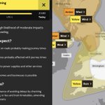
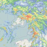
A yellow warning for rain is out, lasting from 11 am to 11 pm today.
1
4
19
1,068
Red sky in the morning, shepherds warning
2
20
677
Red Sky in the Morning @LPL_Airport
1
21
617
Tomorrow looking horrendous for anyone other than a duck
12
14
1
208
9,092
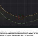
947.9 hPa is the October minimum pressure reading record for the British Isles; Storm Boelo may get rather close - it depends on the pressure readings on the hour (which I believe are used for records rather than minute-by-minute recordings).
2
4
23
2,603
From the document from the Baltasound No. 2 reading last year digital.nmla.metoffice.gov.u…
1
531
Cold conveyor belt associated with Storm Austen now arriving in Reading - steep increase in wind speed, veered NW’ly and temperature drop
1
3
11
1,079
Timelapse from 13:08 to ~13:40, can tell slight changes in cloud movement above towards the end of the timelapse.
7
553
Hello, We have seen a few reports of particularly intense, damaging winds, which occurred around midnight in Portchester and Gosport. If you have any information, including any photos of damage, we would like to hear from you. torro.org.uk/severe-weather-… ~ Sarah
14
24
1,727
Storm Austen this morning at 06:30 UTC from satellite imagery - Scilly St Mary's was up to 76 mph at 04 UTC this morning; unofficial stations have read higher across Cornwall.
2
1
34
1,659
The last of my #StormAusten video spam. Powerful gusts, but also a very strong sustained wind.
16
21
1
109
10,649
Winds have ramped up significantly within the last hour with some powerful gusts of wind here in Hayle, Cornwall. Also a lot of power flashes, very frequent. #StormAusten
6
17
120
7,894
The centre of Storm Austen is starting to become visible on radar; the fronts further east are helping to douse southern England. The strongest winds are currently on the NW flank offshore, but we have some strong southerlies in play (67 mph at Scilly St Mary's).
7
6
34
2,708
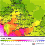
Nowcast model for 23 BST shows these stronger winds offshore; they will move onshore after the centre of the low runs through Cornwall. Rough timings for the strongest winds are around 04 BST on Scilly and 05/06 BST for Cornwall.
1
2
7
754
A busy day for our teams @metoffice with Storm #Austen expected to bring impacts to SW England and W/SW Wales early Friday, and then Storm #Boelo across more northern parts of the UK over the weekend... 🌀 youtube.com/watch?v=-xwVvTEa…
14
10
1
53
6,667
Very neat frontal cloud from Storm Austen - a clear indicator as to when its impacts will start to be felt.
1
1
1
38
1,574
Come on lads - Storm Austen isn’t here just yet
23
1,342
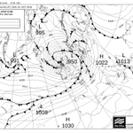
Stunning - the Met Office FAX chart has Storm Austen just offshore the south coast at a pressure of 978 hPa at 06 UTC tomorrow. Cornwall looks set to record wind gusts of 60 - 70 mph widely, and upwards of 80 mph in more exposed areas.
1
3
26
1,342
⚠️ Storm Austen Update: A Channel Islands Red Wind Warning has been issued. Islanders should avoid outdoor activity on Friday morning where possible. Information on Friday closures can be found here: bit.ly/4zFXTWk Weather updates here: gov.je/weather
1
13
1
22
6,458