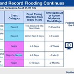
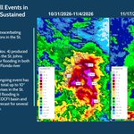
Major and record flooding continue to be observed and forecasted along the St. Johns River. Ongoing rainfall will move out of the area this evening and new rain amounts remain low throughout the week. weather.gov/media/serfc/DSSB…
104
There has been an expansion of major to record flood forecasts on the St Johns River. Some areas are expected to remain elevated for weeks to months. See the full briefing at: weather.gov/media/serfc/DSSB…
This afternoon brings an areal expansion of Major flood category forecasts on the St Johns River, which is expected to remain elevated for weeks to months in some places. See the full briefing at: weather.gov/media/serfc/DSSB…
Check out our November version of the Water Resource Outlook! weather.gov/media/serfc/DSSB…
105
The latest Decision Support Briefing can be found on the web at weather.gov/media/serfc/DSSB…

ALT A combination of strong onshore flow and an upper level disturbance is expected to bring heavy rain through the remainder of the work week to the eastern Florida Peninsula, over the already elevated St Johns River basin. Heavy rain on top of the ongoing river flooding is expected to worsen flooding and/or extend the time in flood categories for locations along the St Johns River. The latest Decision Support Briefing can be found on the web at https://www.weather.gov/media/serfc/DSSBuilder/decision_support_briefing.pdf
This week is #FloridaElNiñoAwarenessWeek and today we focus on the effects of El Niño on rainfall over the state. El Niño winters see increased chances for above normal rainfall and a higher flood risk. Thank you to the Florida NWS offices for their efforts to increase awareness!
3
170
South Florida averages more heavy rain days (2"+) during El Niño winters, however not every El Niño is the same.
Flooding can happen in any phase; 1 heavy-rain setup is all it takes. There have only been 9 Strong El Niño winters since 1950.
#Day3 #FloridaElNiñoAwarenessWeek
There are several resources available for tracking rainfall across Florida this winter!
- Observed Rainfall and Percent of Normal maps (available at water.noaa.gov)
- SERFC Accumulated Rainfall Trackers
#Day3 #FloridaElNiñoAwarenessWeek
Southeast River Forecast Center (SERFC) retweeted
During previous very strong El Niño years, the SE generally experienced wetter than normal winters.
More rain 🟰 higher flood risk
Strong El Niño winters bring above normal rainfall to FL, increasing chances of river flooding across the state.
#FLwx #FloridaElNiñoAwarenessWeek
Southeast River Forecast Center (SERFC) retweeted
🌧️Higher rainfall in El Niño could bring higher river flood risk. Many Florida rivers have experienced historic water levels during El Niño winters and springs.
📋Know your risk for flooding if you live near rivers, streams, canals, creeks, etc.
#FLwx #FloridaElNiñoAwarenessWeek
Southeast River Forecast Center (SERFC) retweeted
⚠️ El Niño winters often bring more heavy rain and a heightened risk of flooding across Florida.
📋Being prepared today can help you remain calm if flooding occurs.
#FLwx #FloridaElNiñoAwarenessWeek
Southeast River Forecast Center (SERFC) retweeted
Following as much as 24 inches of rainfall in areas of FL this week, slow-draining rivers (St. Johns, Peace) are expected to rise into moderate-to-major flood stage. Flood Warnings remain in effect and many roads are closed and flooded. #TurnAroundDontDrown
Rainfall stats for the past month were largely dominated by Isaias. Check out our WRO for a closer look and for a peek ahead into upcoming conditions! weather.gov/media/serfc/DSSB…
112
Isaias is exiting the SERFC area. Locally heavy rainfall, in excess of 9" in places, has resulted in scattered Minor to Moderate flooding. See our full briefing for the associated riverine impacts.
weather.gov/media/serfc/DSSB…
Isaias is now a post-tropical cyclone, and is expected to move out of the SERFC area by tomorrow afternoon. See our full briefing for the associated riverine impacts.
weather.gov/media/serfc/DSSB…
100
Isaias is expected to bring heavy rainfall to much of the Southeast. Significant flooding is possible in areas of heaviest rainfall, with widespread Minor flood and Action stage rises expected.
weather.gov/media/serfc/DSSB…
1
171
Rain brought by #Isaias to portions of the Gulf Coast is expected to cause numerous Action and Minor stage rises, and isolated significant rises, along the rivers in the area. For more details on these expected river impacts, view our briefing here: weather.gov/media/serfc/DSSB…
TS #Isaias has formed and will bring heavy rainfall to the central U.S. Gulf Coast and much of the Southeast from Fri into the weekend. This rain will lead to isolated to scattered river rises in the impacted areas. For more details, view our briefing at weather.gov/media/serfc/DSSB…
Much of the Southeast will see repeated rounds of heavy rain through this weekend. Here’s what we’re watching in terms of river responses. 💧
Did you know that sometimes flooding can be caused by factors other than rainfall? 🧐 Check out this example on the Withlacoochee near Dunnellon, where plants were actually the culprit. For even more information, visit this page from @SWFWMD: content.govdelivery.com/acco… @NWSTampaBay