

Senior Chief Meteorologist. I point at a big green wall early in the morning. Pet peeves: ATM fees and the phrase 'Is it gonna tornado?'
WOWT NBC Omaha
Joined August 2008
- Tweets64.1K
- Following769
- Followers31.2K
- Likes22.6K



Pinned Tweet
Heads up for all those using my feed during severe weather. My posts getting throttled here quite a bit when there are a lot of warnings. Please follow my FB feed for more info. Nothing I can do about it.

Scattered showers starting to fade some in the metro. Steadiest rain will be east and south of the metro the rest of the morning as this all moves east. Some sunshine sneaks out this afternoon.


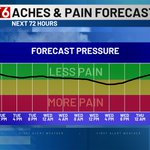
Watch for the air pressure to dip a little bit on Wednesday as the cold front moves through that evening.

Still no threat of a frost or freeze in the near term but there are hints showing up by the end of next week now. That's behind what looks to be a busy start to next week with a large storm system in the Mon/Tue/Wed window. Rain and wind are the story those days as of now.


FIRST ALERT to Friday being a soggy day with rounds of rain and some storms likely. Tough to find the dry windows at this point but there should be a few.
Halloween Saturday has fewer showers but chances in the AM & afternoon. A few are possible during the crucial evening hours


FIRST ALERT to a mild and breezy Wednesday ahead. A few showers are possible before 10am then some clearing takes place. Highs in the upper 70s with wind gusts in the 30-40 mph range are likely. Then a few storms are possible after 5pm that should race east quickly.


FIRST ALERT to some showers out there before 10am today, especially south of I-80. Temps will settle into the 50s behind the rain then try to rebound into the lower 60s this afternoon with some sunshine sneaking through. A few more showers are possible after 9pm tonight too.


The day starts with some showers on the map and temps in the 50s and 60s. We'll cool some before the showers move out by 10am then try to rebound back into the lower 60s this afternoon with some clearing. Light wind overall as well.


As I put the finishing touches on my winter outlook, I thought I would share the snow totals from the last 6 winters. You have to go back to 2020-21 to find a season that topped 20" at Eppley. I'll have my official snow forecast this Thursday!


Through the 25th of October we're currently in 7th place for the warmest Octobers on record. Several warm lows and above average highs could easily bump us up this list this week.

SNOWING like crazy in parts of the panhandle on this Monday morning. The system bringing rain to us is dropping snow on the cold side out west. A few slushy inches likely add up in spots from Scottsbluff to Chadron this morning.


We've officially had a frost in the metro but no official freeze just yet for the record books. We'll likely get to the first week of November with that being the case. That's when we'll have to start watching this list closely.

Everything look good for the blackout game in Lincoln this Saturday night. Comfortable temperatures for late October with lighter evening wind. There is a small chance of a spotty shower or two but a washout is not expected as of Monday.

FIRST ALERT to that #Halloween forecast that doesn't look too bad at the moment. 60s fall into the 50s that evening. South gusts to 20 mph during the day will decrease around sunset. A few spotty showers are possible but a washout isn't likely at this point.

So officially the coldest temperature for the metro is 34 degrees back on the morning of the 17th. Many of us did dip near 30 degrees though. Nothing like that the rest of the month though. No worries of a frost or a freeze.


