

19 Y.O | Severe Weather Enthusiast | Storm Chaser | I talk Weather nothing else. |🌪= 1
Missouri, USA
Joined July 2021
- Tweets7.6K
- Following50
- Followers710
- Likes9.3K




Storm Captures Pictures/Videos retweeted

🌪 Registro del martes 17.11.26 por la tarde en el sector Barahona, en la bajada de El Teniente, en la precordillera de O'Higgins.
Video del dron @diego.arriaza92 en Tiktok (autorizado)
Se trataría de un tornado, según análisis preliminar de @rondax_en
#megatiempo
@meganoticiascl @Mega
Storm Captures Pictures/Videos retweeted

11/14/2026 - Check this out! One of my followers near Seminole, TX sent me these pictures of what appears to be a tornado from earlier this evening! These pictures were taken at 6:01 PM CST about 8 mile east of CR 1429 in Seminole, TX. Did anyone else lay eyes on this? #TXwx #Tornado #SevereWeather


Storm Captures Pictures/Videos retweeted

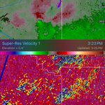
It appears a brief tornado may have occurred northwest of Lamesa, Texas an hour ago. A mini-supercell exhibited a velocity couplet with 31.6 kt VROT, co-located with an area of enhanced reflectivity (dBZ), reduced correlation coefficient, and lowered differential reflectivity (ZDR) values, potentially indicating a tornado debris signature. The PTDS product also appears to be detecting this feature.

Storm Captures Pictures/Videos retweeted

Atualização da classificação de intensidade do tornado que atingiu os municípios de Senador Salgado Filho, Giruá e Sete de Setembro (RS) em 28 de julho de 2026.
Uma análise adicional, conduzida por nossos colaboradores da Universidade Federal de Santa Maria (UFSM), foi realizada sobre os danos causados à vegetação. Ao longo do trajeto percorrido pelo tornado, foram observados trechos em que cerca de 60% ou mais das árvores nativas de tronco rígido apresentaram descascamento acentuado dos troncos.
Não obstante, imagens aéreas georreferenciadas foram utilizadas para a aplicação do modelo desenvolvido pelo Canadian Severe Storms Laboratory (CSSL), o qual utiliza modelos analíticos do perfil de ventos em um vórtice tornádico para estimar a velocidade do vento a partir do padrão de queda de árvores (tree-fall pattern analysis). Em um dos trechos analisados, o padrão de quedas de árvores provocadas pelo tornado apontou para ventos que superaram o limiar inferior de um tornado de intensidade EF/F4.
A estimativa dos ventos nos demais trechos, em particular os estragos observados nas construções civis permanece inalterada em F3, assim como a largura da faixa de destruição e a extensão total percorrida pelo tornado.
Em suma, este tornado terá sua intensidade máxima estimada elevada de F3 para F4.
Todo este trabalho foi apresentado no primeiro Simpósio Sul-Americano de Tempestades Severas (I SSTS) que ocorreu esta semana em São José dos Campos.


Storm Captures Pictures/Videos retweeted

@NWS_MountHolly apparently just outside of Christiana hospital. Not my vid. The brother of a coworkers vid.
Storm Captures Pictures/Videos retweeted

Tornado on the ground just outside of Wilmington, DE this afternoon

Storm Captures Pictures/Videos retweeted

@NWS_MountHolly tornado on webcam. On 495 just north of Edgemoor (1859z)

Storm Captures Pictures/Videos retweeted

RARE TORNADO in Wilmington, Delaware, just moments ago!
The last time a tornado happened this late in the year in Delaware was 1989.

Holy crap they it’s about time they get one close to me

BREAKING: A NEW RADAR SITE is coming to southeast Missouri, filling one of the largest radar coverage gaps in the United States!
The radar will be built near Van Buren, Missouri, where the lowest radar beam currently passes roughly 13,000 FEET above the ground!
This $2 MILLION+ project aims to dramatically improve severe weather detection and warning capabilities across the region.
Construction is expected to be completed by June 2027. This should be a public radar site, as it's being funded with taxpayer dollars.

29
Storm Captures Pictures/Videos retweeted

Missed the anniversary by a day but man, November 4, 2022 was probably one of the craziest fall chases in recent memory.
We caught the photogenic EF2 near Sulphur Springs, TX and then raced to keep up with the storm for the next hour or so. Just before dusk, the storm produced the massive EF-4 near Clarksville, which we got a few brief glimpses of before it raced off into Oklahoma.
Really the last impressive fall outbreak I can recall in the Southern Plains.
Storm Captures Pictures/Videos retweeted

I know not rated as such but come on Washington is such an EF5


Storm Captures Pictures/Videos retweeted

This storm in Bibb County Alabama has been consistently exhibiting decent rotation. Taken near Brent AL. #ALwx @spann @CarlynsWx @AlabamaWXNet @rblackwell_wx @weswyattweather @TaylorSaralloWX @Sadiemorristv @mattdanielwx @Dave_Nussbaum @weatherwaiyana @BryleeWVTM13 @megtomwx @simpsonWVTM13 @toniatalkss @LainepughWX @StephWVTM13 @LaurenLinahan

Storm Captures Pictures/Videos retweeted

Algumas imagens da destruição no aeroporto de Chapecó, após uma forte tempestade atingir a cidade.
O Aeroporto Serafim Enoss Bertaso está com as operações suspensas por tempo indeterminado.


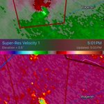
How is this not warned, we may have a strong tornado south of Wilton, AL. Significant TDS on radar now.

1
2
159
Holy crap that’s really scary

An impressive wedge tornado struck the airport and an aircraft in the city of Chapecó, Santa Catarina, Brazil, earlier today. Radar imagery captured by the Previsão Masters app (previsaomasters.com).
1
135
Storm Captures Pictures/Videos retweeted

🌪️ Tornado in Kansas City this morning? What do y’all think? This was taken around 7:30 AM by Ryan Wilkins near KU Med, looking north. There were scattered storms in the vicinity at the time. Perhaps a gustnado, some other type of scud cloud or steam? I need to do some more digging into the radar data and other atmospheric conditions from that time.
Posted Tuesday November 3, 2026.


Storm Captures Pictures/Videos retweeted

Fully condensed tornado just now southwest of Lewiston, Louisiana. Video soon. @ryanhallyall @WxWiseApp @NWSLakeCharles
