


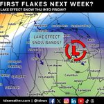


❄️ 𝗙𝗜𝗥𝗦𝗧 𝗙𝗟𝗔𝗞𝗘𝗦 𝗢𝗙 𝗧𝗛𝗘 𝗦𝗘𝗔𝗦𝗢𝗡 𝗧𝗛𝗜𝗦 𝗪𝗘𝗘𝗞?
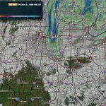
A cold front will drop temperatures 10-20 degrees Thursday. Couple that with strong northerly winds and we get our first shot at some snowflakes Thursday evening through Saturday! They'll likely be mixed with rain and aren't expected to accumulate due to warm ground temperatures.
Are you excited or not ready for snow yet? #INwx #OHwx #MIwx #winter #weather #snow

🌨️ WATCHING FOR LAKE-EFFECT SNOW LATE THIS WEEK INTO THE WEEKEND
A deep upper-level trough will move across the region late this week and into the weekend, creating conditions that could support lake-effect snow. It may bring the season’s first flakes to parts of the Great Lakes and Ohio Valley.
Accumulations and impacts are expected to remain very limited. Above-average temperatures this fall have kept the ground warm, while warmer Great Lakes waters may help raise temperatures downwind of the lakes.
A few spots could see a trace to a light dusting of snow on grassy surfaces overnight or during the early morning hours. No travel impacts are expected. #INwx #MIwx #ILwx #OHwx #WIwx

HOW MUCH SNOW DOES IT TAKE TO CANCEL SCHOOL? ❄️🏫
While we're still waiting for our first flakes of the season, it won't be long before we're talking about school delays and cancellations!
So, how much snow does it typically take to call a snow day in Indiana? Many schools may consider closing when snowfall reaches 3–6" or even 6–12" over a 24-hour period, depending on road conditions and timing
Do you agree? How much snow does it take to close schools in your area? Let us know in the comments! 👇
#INwx #winter #snow #snowday

TEMPERATURE ROLLER COASTER AHEAD! 🌡️
After a chilly weekend, warmer air is on the way as we head into the workweek! Above-average temperatures are expected across the region over the next five days, bringing a noticeable warm-up.
However, don't get too comfortable! Another surge of colder air is expected to move into the region, bringing a return to below-average temperatures across the Ohio Valley for several days. Current data suggests this colder pattern will be most noticeable during the Days 6–10 period.
We'll continue to monitor how this pattern evolves! #INwx #ILwx #OHwx #MIwx #WIwx

❄ FIRST FLAKES OF THE SEASON POSSIBLE LATE NEXT WEEK?
A strong upper-level trough is expected to dig south across the region late next week, bringing a shot of much colder air!
As winds shift out of the north, colder air moving across the relatively warmer Great Lakes could create favorable conditions for lake-effect snow showers. This could give portions of the region their first snowflakes of the season!
It's still too early to determine how far south any snow showers could reach, but it's something we'll be keeping an eye on as we get closer! #INwx #ILwx #OHwx #MIwx #WIwx

COLD AIR MID-MONTH?
Data continues to point toward another shot of colder air arriving November 12–15. The big question now is just how cold it could get!
EURO ensemble guidance suggests temperatures running around 3–8° below average, while the GFS ensemble is showing a potentially stronger push of cold air, with some areas running 5–15° below average.
There is still some uncertainty regarding the strength and extent of the colder air, but this is something we'll be keeping a close eye on as we head into the coming week! #INwx #ILwx #OHwx #MIwx #WIwx

COLD START TO THE WEEKEND! 🥶
If you have been waiting for a return to colder weather, the next couple of days are just for you!
Saturday morning will bring widespread temperatures in the 20s and 30s across the region, with portions of the Mid-Mississippi River Valley likely experiencing their first freeze of the season!
Daytime temperatures won't offer much of a warm-up either. Highs on Saturday will top out in the low to mid-50s across much of the region, making for a chilly start to the weekend!
Time to break out those jackets! 🍂 #INwx #ILwx #OHwx #MIwx #WIwx

❄️ WINTER WEATHER UNCOVERED! ❄️
Ever wondered how snow and ice form, how meteorologists predict winter storms, or what you can do to stay safe when winter weather arrives?
Join us for Winter Weather Uncovered at the Owen County Public Library in Spencer, Indiana, on Monday, November 16th, at 6:00 PM!
We'll cover everything from the science behind snow and ice to how meteorologists forecast winter storms, winter weather safety, and even take a look at what we might expect for the upcoming winter season!
Whether you're a weather enthusiast or just want to learn more about the weather we experience every winter, there's something for everyone!
📍 Owen County Public Library – Spencer, IN
📅 Monday, November 16th
🕕 6:00 PM
We hope to see you there! Find more information here: owenlib.org/events/winter-we… #INwx

A LITTLE SNOW FOR PORTIONS OF THE GREAT LAKES TONIGHT!
Most of us are still waiting to see some of the white stuff, and for many, that wait will continue a while longer. However, portions of the Northwoods and Michigan's Upper Peninsula will see some snow develop late tonight into tomorrow morning.
Don't expect much in the way of accumulation, though! Amounts will be very limited, with a few locations potentially picking up a trace to a light dusting.
#MIwx #snow #greatlakes

An area of low pressure will bring showers and drizzle across the region later today through tomorrow. However, for most of us this will prove to be just pesky activity with little in the way of accumulations.
Greater amounts will be focused for areas closer to the Great Lakes where the storm will create some lake effect rain showers. #INwx #ILwx #OHwx #MIwx #WIwx

3
386
SUNSHINE AND SEASONAL TEMPERATURES THIS WEEKEND!
An area of low pressure will continue moving across the region later today and into Friday, bringing increased cloud cover and a few chances for light rain across portions of the region.
However, conditions will begin to improve as high pressure builds into the region heading into the weekend. This will bring a return to sunshine, along with cooler temperatures that will be much closer to seasonal averages!
Overall, Saturday and Sunday are shaping up to be a beautiful fall weekend across much of the region! ☀️
#INwx #ILwx #OHwx #MIwx #WIwx

Our official Winter 2026-27 Outlook will be issued TOMORROW to clients at tdsweather.com!
📈 Record El Niño
🌡️ Temperature trends
💧 Precipitation trends
❄️ Official snowfall forecast
🔀 Active storm tracks
🔍 Historical context
Inquire for access: [email protected]
#INwx #ILwx #OHwx #MIwx #WIwx #winter #weather #snow

COOLER AIR RETURNS LATE WEEK! 🍂
After an extended stretch of well-above-average temperatures, cooler air is expected to move into the region late this week and stick around into the weekend!
High temperatures on Friday and Saturday will generally range from the upper 40s to 50s across the region, bringing temperatures closer to, and in some areas slightly below, seasonal averages.
A much more seasonable feel is on the way as we head into the weekend! #INwx #ILwx #OHwx #MIwx #WIwx
AM REGIONAL WEATHER UPDATE
Rain continues across the Ohio Valley this morning, with the heaviest precipitation focused across portions of Indiana, Ohio, and Kentucky.
This rainfall is moving out ahead of an approaching cold front. Temperatures ahead of the front remain in the upper 50s and 60s, while cooler air behind the front has already dropped temperatures into the upper 40s and 50s.
That cooler air will continue spreading across the region throughout the day and into tonight, bringing a noticeable change in temperatures!
#INwx #ILwx #OHwx #MIwx #WIwx

WEATHER MODELS RETIRED TODAY!
If you've been looking for the NAM, NAM 3km, and their overnight runs, the 06z run was the final one for these models.
After several delays to their retirement dates, the RRFS and REFS will officially take their place. Whether that's for better or worse remains to be seen!
It will be interesting to see how these new models perform, especially as we head into the winter season when forecasting accuracy becomes even more important. It'll take some time to evaluate their performance, but we're looking forward to seeing what they bring to the table!
#INwx #ILwx #OHwx #MIwx #WIwx #weather
🤖 Made with AI

💨 BREEZY CONDITIONS TODAY!
Winds will ramp up across the region today ahead of an incoming storm system. While much of the region can expect wind gusts of 20–30 mph, portions of Illinois, southern Wisconsin, and northwestern Indiana could see stronger gusts of 30–40 mph!
Be sure to secure any loose outdoor objects and bring in those fall decorations before the winds pick up! 🍂💨 #INwx #ILwx #OHwx #MIwx #WIwx

Our official Winter 2026-27 Outlook will be issued to clients THIS THURSDAY in our weekly long-range outlook! We'll discuss expected temperature and precipitation trends, pattern drivers, active storm tracks, similar years in history, and of course our snowfall forecast. Inquire for access: [email protected]
#INwx #ILwx #OHwx #MIwx #WIwx #winter #weather #snow #snowremoval #snowandice #snowandicemanagement
🤖 Made with AI

🍂 COOLER TEMPERATURES RETURN LATER THIS WEEK!
If you've been waiting for a return to more seasonable fall temperatures, relief is on the way! A strong area of low pressure and an associated cold front will move across the region tomorrow night into Wednesday, ushering in a much cooler air mass.
While temperatures will still remain slightly above normal heading into the end of the week and weekend, highs in the 50s and 60s will feel much more like fall compared to the warmth we've experienced recently!
A much-needed taste of fall is on the way! 🍂
#INwx #ILwx #OHwx #MIwx #WIwx

🌧️ MUCH-NEEDED RAINFALL HEADED OUR WAY THIS WEEK!
It's been exceptionally mild and dry across much of the region recently, allowing drought conditions to expand over the last several weeks. Fortunately, some much-needed rainfall is finally in the forecast!
An active weather pattern, with multiple disturbances moving through the region, will bring several opportunities for rain this week. By the end of the week, widespread rainfall accumulations are expected, with 0.50–1.00" across much of Illinois, central and southern Indiana, and southern Ohio.
Some areas south of the Ohio River could see even higher totals, with 1–2" of rainfall possible!
While this won't eliminate ongoing drought concerns, it should provide some beneficial relief to areas that have been running very dry.
We'll continue to monitor rainfall trends and keep you updated! 🌧️ #INwx #ILwx #OHwx #MIwx #WIwx
