

UK Thunderstorm lover, Photography sometimes, and chasing!
Joined June 2025
- Tweets1.7K
- Following336
- Followers362
- Likes33.7K


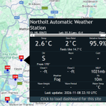


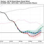
Very dangerous conditions out there near Heathrow. You can barely see the road from this traffic camera - imagine driving in this!


Extremely dense fog ongoing: Heathrow airport has also now reported a visibility of just 10 meters. Google Maps suggests multiple crashes have occurred near the area due to this localised extremely dense fog, with absolutely awful traffic conditions.


Some extremely dense fog developing in some areas. Visibility of just 10 meters has been reported in Northolt.

Furthermore, fog is starting to develop in areas of SW Northern Ireland. The Met Office have just issued a yellow warning to cover that threat.

Fog is starting to develop across the country as for the third night in a row a Yellow Fog Warning is in force.
The map to the left shows observed visibility in meters.


JamesWeather retweeted

Let me save you all some article reading time...
Will the earliest weakening of the polar vortex on record bring snow to the UK?
Nobody knows.
THE END.
JamesWeather retweeted

Largely clear skies across England & Wales gave a unique chance to study the temperature response to the 12th Aug 2026 solar eclipse — a rare evening eclipse ☀️🌗🌍
Screen temp reached a mean anomaly of –1.8°C ~16 mins after max eclipse 📉
@RMetS paper: rmets.onlinelibrary.wiley.co…

JamesWeather retweeted
7:00am CST #SPC Day1 Outlook Enhanced Risk: across north-central Oklahoma and south-central Kansas spc.noaa.gov/products/outloo…

Looking at current visibility reports, shown here in m via weatherobs.com, you can see already the extent of dense fog across southern and central England, and areas of wales.

For the third day running, A yellow fog warning has been issued by the Met Office. Take care on the roads tomorrow morning as fog may be dense.


JamesWeather retweeted

Our analysis of damaging "straight-line" winds that impacted parts of S. Yorkshire + Lincolnshire on evening of Sunday 29 March 2026 has been published 📖
Meteorological setup in @RMetS "Weather" journal: rmets.onlinelibrary.wiley.co…
Detailed damage reports: torro.org.uk/research/event

JamesWeather retweeted

Oh come on GFS, 12 November is too early for snow in SE England 😆
The model has been hinting at much colder air spreading south into the 2nd week of November over recent operational runs, though they have been cold outliers in the ensembles.
Very much depends on where the blocking high migrates...

JamesWeather retweeted
On Sun 29 March 2026, damaging winds occurred in South Yorks and Lincs associated with shallow convection just 3–4 km deep. Radial velocities of up to ~80mph were detected.
The event has been published as a Spotlight article in @RMetS journal "Weather": rmets.onlinelibrary.wiley.co…

Fun fact: under the current met office system, a Red weather warning for fog is impossible and can't be issued.
This is because there are no extreme impacts listed on impact tables, needed for a red warning.

JamesWeather retweeted

ECM zonals are now going for a reversal of winds AKA: Sudden stratospheric warming achieved. Also a slower recovery.
Watch out for the end of November and early December... 👀👀

