

Geospatial Professional sharing knowledge related to ArcGIS Pro, ArcGIS Online, ArcPy, and the ArcGIS API for Python. Automating my way to retirement!!
Kildare, Ireland
Joined January 2016
- Tweets80
- Following168
- Followers93
- Likes94








Free ongoing course for Automating ArcGIS Online Feature Service Workflows with the ArcGIS API for Python
youtube.com/playlist?list=PL…
#ArcGISAPIforPython #ArcGIS #LearnArcGIS #ArcGISOnline


Download an Available #Survey123 Form from #ArcGISOnline using the #ArcGISAPIforPython and Replicate in Survey123 Connect
learn.finaldraftmapping.com/…

Free #ArcPy course: Master ArcPy Search, Insert, and Update Cursors with #ArcGISPro
youtube.com/playlist?list=PL…


List Excel File Sheet Names as an Input Parameter for Custom tools in #ArcGISPro with #ArcPy & #Pandas
learn.finaldraftmapping.com/…

Happy GIS Day! Here's a free course all about using ArcPy and Definition Queries in #ArcGISPro
youtube.com/playlist?list=PL…

Create Rectangle Buffers for Point Features in #ArcGISPro Using #ArcPy
learn.finaldraftmapping.com/…

How to check if an #ArcGISOnline Feature Service is a View Layer with the #ArcGISAPIforPython
learn.finaldraftmapping.com/…

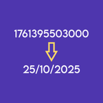
Convert #ArcGISOnline Epoch Time to DD/MM/YYYY or other format using the #ArcGISAPIforPython
learn.finaldraftmapping.com/…

Merge multiple CSV files and create a point feature class in #ArcGISPro with #ArcPy
youtu.be/Up7eUtS9Y-8

Create a WebMap in #ArcGISOnline with the ArcGIS API for Python.
One of our most visited blog posts!
learn.finaldraftmapping.com/…

Final Draft Mapping retweeted

PostGIS Day 2025 is almost here! Next week, November 20 (that's the day after GIS Day), over 20 talks about our favourite spatial database. Sign up now, there's a finite number of webinar slots and an infinite about of interest! snowflake.com/postgis-day-20…

Save Geography at the University of Leicester - Sign the Petition! c.org/x22jmM2Gpb via @Change
Label Features in ArcGIS Online Web Maps Using the ArcGIS API for Python | Step-by-Step Tutorial
youtu.be/SJELQtH-il0
#ArcGISAPIforPython #ArcGISOnline #ArcGIS

What can we do to create more value from geospatial data? @OrdnanceSurvey increasingly making geospatial data openly available since 2010 #ODISummit

Final Draft Mapping retweeted

New tutorial series for GIS professionals: “How Do I Do That In #FME?” Learn which FME transformers to use to accomplish 38 common #GIS tasks. buff.ly/2Ny57UT @SafeSoftware

ALT How do I do that in FME
More maps drawn by my grandad in 1939 depicting the leading Irish industries at the time @IrishEconAssoc @IDAIRELAND #1939 #beforeGIS

A map drawn by my grandad in 1939 as schoolwork showing the Irish railway network @IrishRail #beforeGIS

Final Draft Mapping retweeted
Fantastic Career Opportunities now on offer with IMGS. Roles include Part-time IT Project Manager, GIS Technician & IT Graduate. Click the link for full details for each role. buff.ly/2otPEvn #jobfairy #ITJobs

ALT IMGS Logo