

Founder & CEO, @terrawatchspace | Earth Observation Strategist & Advisor | Satellite Data for Businesses, Climate & Environment
Earth
Joined July 2010
- Tweets8.5K
- Following1.2K
- Followers9.6K
- Likes72.4K





Pinned Tweet
This essay has been months in the making and leverages everything I have learned about Earth observation over nine years of consulting in the sector across EO companies, enterprises using EO and investors.
It is the longest piece I've written and likely the most controversial.

I have been in Earth observation for the past decade and for most of that time the traditional model for EO has always been "technology-led": build and demonstrate a new sensor/satellite, try to identify applications and users.
Then once in orbit, push the technology into the market and wait for adoption, before starting the cycle again with the next generation of sensors.
No wonder EO adoption was slow because the process began with what satellites can do and not what (and in which form) the users needed the information.
However, since the last few years we are slowly moving towards a "problem-driven" EO strategy, which reorders that logic slightly: start with the problem, verify if it is actually a problem worth solving, whether EO is really needed and whether we need more satellites.
Only after these questions are answered does the original 4 questions come in.
TL;DR: I think the overall goal is to move from pushing data outwards and hoping it finds traction to pulling technology inwards and aligning it with defined needs.

Aravind 🌍 🛰 retweeted

The reason satellites keep missing Africa's informal settlements isn't resolution. It's that colour imagery can't tell a slum from an ordinary dense neighbourhood, and radar can.
Getting them onto a map matters more than it sounds. Informal settlements are where a large share of urban Africa actually lives, and if a city can't see them, it can't plan water, sanitation, roads or disaster response for them. The obvious tool is satellite imagery, but the ordinary kind measures colour and brightness, and here that betrays you. A tightly packed formal neighbourhood of small concrete houses reflects light in much the same way as an informal settlement of tin-roofed shacks. To the sensor the two blur together, so the settlement gets folded into the surrounding city and vanishes from the count.
A team from Sapienza University of Rome and the University of Pavia found a way to pull them back apart, and the trick is to stop relying on multispectral images and start listening to structure. Alongside the usual optical imagery they brought in radar from the Sentinel-1 satellites, which doesn't care what colour a roof is. Radar bounces off shape and material, off the angles and clutter of how buildings sit together, and informal settlements have a very particular texture from above: irregular, densely packed, metal-roofed, jumbled at odd angles rather than laid out in neat blocks.
They fed that radar signal in through three escalating layers. First the raw strength of the return. Then the texture, a measure of how rough and disordered the radar pattern is across a patch of ground. Then a physics-guided index tuned to the specific fingerprint of a slum, the weak, scattered returns you get from small chaotic structures. To train and test it they used expert-drawn labels from very high-resolution imagery, roughly 426,000 pixels' worth, across Nairobi and Eldoret in Kenya, with a further check in Kigali, Rwanda.
The payoff shows up exactly where the problem was. Judged on how well it finds informal settlements specifically, an optical-only map scored 0.44 in the dry season, roughly a coin toss dressed up as a classifier. Adding the radar layers lifted that to 0.67, and in the wet season from 0.52 to 0.68. Overall accuracy landed around 81.6% in the dry season and 80.7% in the wet, beating the standard reference product's 70.4%, and the mislabelling of informal areas as ordinary dense housing fell by about 7 percentage points.
The seasonal detail carries more weight than it first appears. Optical imagery drifts with the weather, greener in the wet season, dustier in the dry, which is part of why maps built from it wobble month to month. The radar texture barely moved between seasons, so the settlement stayed visible either way. Obviously, a map you can only trust half the year is not much of a map, and this is one step to fixing that.
link to full article: arxiv.org/abs/2607.07532

Aravind 🌍 🛰 retweeted

ECMWF 🇪🇺🇬🇧has upgraded their world-leading weather model open-source data (that's free to you and me) to 0.1° --> full resolution!
Amazing news for the world, weather map makers --> enormous improvements for machine learning, forecasting, everything. 🎉
If you, your kid or the kid inside you wanted to learn about how Earth observation satellites work, @Sina_Kashuk with the help of Claude has created something amazing.
Simple explanations on how all the different types of EO satellites (about 109 of them) work to pique your interest and make you wonder.
fused.io/share/fc_34KmH7Yrc3…

I included screenshots of two of my favourite satellites - Landsat 1 (the one that started the 50-year photo album) and GRACE (the ones called Tom and Jerry).
I hope teachers will use these in science classes to make the next generation fascinated about Earth and the science of studying it.


I also liked the "Wow Fact" section. Some of my favourites - I will let you guess the satellite:
- "For years, the hills and valleys in video games, flight simulators and phone maps came from my 11 days of work."
- "Before me, pictures this sharp were a military secret. After me, they ended up in everyone's phone map apps."
- "I carry two very different jobs on one satellite to save money, like a mail truck that also delivers pizza."
Aravind 🌍 🛰 retweeted
“Sovereignty” is probably the most overused term in the Earth observation sector today. According to TerraWatch analysis, we track at least 76 governments that have either announced or have ongoing activities related to deploying their sovereign EO solutions.
But how sovereign is sovereign?
Some countries are buying dedicated satellites from companies that deliver them in less than a year, some countries are reserving exclusive capacity on commercial EO satellites and others are commissioning fully nationally built and owned constellations. But all of these are called "sovereign."
A better way to think about sovereignty is perhaps as a stack of control points across the EO value chain. So, I recently came up with 10 layers of sovereignty that go all the way from one end to the other.
1. Industrial sovereignty
2. Deployment sovereignty
3. Asset sovereignty
4. Operations sovereignty
5. Collection sovereignty
6. Access sovereignty
7. Data sovereignty
8. Processing sovereignty
9. AI model sovereignty
10. Application sovereignty
In the latest edition of the @terrawatchspace Pro newsletter, I detailed the 10 layers of EO sovereignty, analysed whether any EO system can be fully sovereign, discussed the differences between sovereignty and autarky and what the future of EO sovereignty would look like.

Aravind 🌍 🛰 retweeted

Making AI weather models open source is even better if people can actually run them!
Over the past few months, I wrote two blog posts on this topic:
⛅ Run AI weather forecast models on the Hub with Earthmover’s data: huggingface.co/blog/hugging-…
🌍 Run ECMWF’s AIFS Single 2.0 on any GPU or with HF jobs: huggingface.co/blog/hugging-…
I'd love to hear what difficulties you're running into when using AI weather forecasting models 👀

“Sovereignty” is probably the most overused term in the Earth observation sector today. According to TerraWatch analysis, we track at least 76 governments that have either announced or have ongoing activities related to deploying their sovereign EO solutions.
But how sovereign is sovereign?
Some countries are buying dedicated satellites from companies that deliver them in less than a year, some countries are reserving exclusive capacity on commercial EO satellites and others are commissioning fully nationally built and owned constellations. But all of these are called "sovereign."
A better way to think about sovereignty is perhaps as a stack of control points across the EO value chain. So, I recently came up with 10 layers of sovereignty that go all the way from one end to the other.
1. Industrial sovereignty
2. Deployment sovereignty
3. Asset sovereignty
4. Operations sovereignty
5. Collection sovereignty
6. Access sovereignty
7. Data sovereignty
8. Processing sovereignty
9. AI model sovereignty
10. Application sovereignty
In the latest edition of the @terrawatchspace Pro newsletter, I detailed the 10 layers of EO sovereignty, analysed whether any EO system can be fully sovereign, discussed the differences between sovereignty and autarky and what the future of EO sovereignty would look like.
Become a paid subscriber to get weekly briefings with exclusive insights and analysis!
Read more here: newsletter.terrawatchspace.c…

Aravind 🌍 🛰 retweeted

BIG: A Russian military satellite, Kosmos 2612, has been maneuvering to within 136 meters of the U.S.-registered ICEYE-X36 radar imaging satellite, according to satellite trackers, with a closer pass of about 48 meters predicted for Monday.
Dutch satellite tracker Marco Langbroek said a series of maneuvers since September 30 were designed to match the satellite’s orbit with ICEYE-X36’s.
Astronomer Jonathan McDowell called it the first known case of an active satellite making an uninvited close approach to another active satellite in low Earth orbit.
ICEYE, a Finnish company, has supplied radar imagery to Ukraine since 2022, though it is unclear whether this satellite serves Ukraine.
There are no signs of damage so far, and Russia’s intentions remain unclear.
Another SpaceX Falcon-9 ride share mission (this time to a mid-inclination orbit), another Earth observation-dominated launch manifest.
As has always been the case, at least half of the payloads launching on Bandwagon-5 are EO satellites.
- 9 imaging: ICEYE ×4, Capella ×2, Umbra ×2, Planet Pelican ×1
- 3 weather/atmospheric: Tomorrow io ×2, PlanetiQ ×1
- 3 RF: HawkEye 360 ×3
(and possibly SIRIUS-A & SIRIUS-B)

Teams encapsulated 32 payloads ahead of Falcon 9’s launch of the Bandwagon-5 rideshare mission from Florida → spacex.com/launches/bandwago…

The interdependence of EO satellites on SpaceX (and vice versa) is a trend across Transporter and Bandwagon missions 👇
xitter.cf/aravindEO/status/21056…

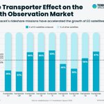
According to @terrawatchspace analysis, on average about 53 % of all payloads launched on SpaceX Transporter rideshare missions are EO satellites.
So, if you were wondering which segment of the space industry is going to be affected the most with the Falcon 9 phasing out 👇

Aravind 🌍 🛰 retweeted
As AI and Earth observation start to converge with embeddings, EO foundation models and geo agents, I see basically three kinds of moat for EO and EO-related companies in the future:
i) those that have proprietary EO data that is unique in spatial/spectral resolution, quality, revisit or historical archives
ii) those that have established customer relationships, distribution channels and the knowledge and experience of integrating EO into operational workflows of the end-user
iii) those that possess deep domain expertise and proprietary training/ground-truth data relevant for specific EO applications
I think many of the other moats that EO-based companies rely on today (like simple object detection, feature extraction or non-contextualised change detection) are likely to be disrupted or commoditised in some form.
Aravind 🌍 🛰 retweeted
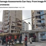
The next time someone says satellite data gives you the objective truth, think again and look deeper - depending on the sensor used, how damage is defined, the methodology and what you are trying to measure, two EO products can give you technically valid yet very different answers.
This piece uses the June 2026 Venezuela earthquakes as a case study to show how seven damage assessment projects produced very different estimates of damaged buildings.
Takeaway: When someone promises you a black-box EO solution that gives you an answer, it is worth looking under the hood and understanding what exactly is being measured, how and with what limitations.
That may not apply to every use case (like reporting and simple high-level analysis), but it is especially true for anyone that is using an EO-based solution for critical decision-making.
hotosm.org/en/news/why-damag…
Aravind 🌍 🛰 retweeted

In addition news and insights on Earth observation and applications, the latest edition of the TerraWatch Pro newsletter includes an in-depth analysis of the latest EO budget request from Japan.
Japan's FY2027 budget proposal is a good representation of how the three segments of EO development are evolving at the same time:
i) government is continuing to build strategic observing infrastructure,
ii) becoming a much larger customer for commercial EO data, and
iii) embedding satellite-derived information into downstream public services.

Aravind 🌍 🛰 retweeted

All 4.5 years of the war in Ukraine through satellite fire detections. You can see the border line up clearly in waves. Staggering to see it from this point of view.
Aravind 🌍 🛰 retweeted
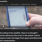
Here's a really interesting Earth observation case study from France - in this case, the real-world challenges associated with using EO solutions.
France uses satellite-based estimates of pasture growth to help determine whether farmers are eligible for drought compensation.
The problem is that, in some places, what the EO-based estimates says and what farmers actually see on the ground do not match. So, some farmers are not getting compensated even when drought has severely affected their pastures.
In the insurance industry, this kind of gap between what the model says and what is actually happening is called 'basis risk'.
Quick context: Decisions here are made using the "pasture production index" indicator - which uses satellite observations of vegetation combined with rainfall, temperature, altitude and terrain data to estimate how much grass has grown over the season.
The problem? According an independent researcher, the model uses outdated ground data from 2019 limiting how well the EO solution reflects conditions on the ground. So, while EO is supposed to make farmers' lives better, it is doing the opposite.
A good reminder for the EO community: just because an EO-based solution is deployed and used doesn't mean the story is over. The more EO is used for real-world decisions (especially something as sensitive as farmer payouts), the more important ground truth and continuous validation become.
And, this is also a good example of the "capability - use case gap" I talk about all the time - just because EO can see something does not mean it is a solution that works for a user, which requires a lot of constant work.
PS. If you want to learn more about EO for parametric insurance, you can buy our recently published report which includes opportunities, challenges and case studies (link in comments).
