

Exploring the geography and history of Ethiopia and the surrounding region through maps, data, and visuals.
- Tweets1.9K
- Following168
- Followers1.9K
- Likes6.8K

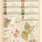


ALT Ethiopia, Somalia, Kenya, Uganda, Rwanda, Tanzania, Burundi Pergamon World Atlas By the Polish Army Topography Service Published by Pergamon Press, Ltd. & P.W.N. Poland, 1967 This atlas page was created during a period marked by post-colonial transitions in Africa. Many of the countries depicted gained independence in the early 1960s, and the atlas reflects the geopolitical realities of that era, emphasizing newly established national identities and economic potentials. The detailed thematic maps and data also hint at development priorities, such as agriculture and industrialization, which were focal points for many African nations in their development agendas during the 1960s.

ALT Arabia By Général de la Marine Published by Dépôt de la Marine (French Hydrographic Office) Paris, 1833 Inset: Denis Bay, Mocha, Kamaran Island,

ALT The Aero Relief Map Of Africa By Aero Service Corporation Philadelphia, 1961 The primary focus of this map is the topography of Africa. It highlights significant mountain ranges such as the Atlas Mountains in the northwest and the Ethiopian Highlands in the east. The Great Rift Valley is also prominently featured, extending from the Middle East down through eastern Africa. Major rivers like the Nile, Congo, and Niger are visible, contributing to the understanding of Africa's hydrography. The Aero Relief Map of Africa stands out for its ability to convey complex topographical information in an accessible and engaging format, making it an essential tool for educators, geographers, and historians alike.

ALT Map of the Nile River, Egypt, Nubia, and Abyssinia By Adam Christian Gaspari and F.L. Guessefeld Published by the Geographic Institute of Weimar Germany, 1817 The map is part of an atlas which represents a transition from the 18th-century mapmaking style to a more modern 19th-century German approach, characterized by the use of hachures for relief depiction and more uniform typography.

ALT Nubia and Abyssinia to Bab El Mandeb By Sharpe, J., Lowry, J.W. Published by Chapman and Hall London, 1848 The work titled "Nubia and Abyssinia to Bab El Mandeb" is part of Sharpe's Corresponding Maps, published in 1848 by Chapman and Hall. This map, engraved by Joseph Wilson Lowry. It was featured in a world atlas. The map encompasses regions of present-day Eritrea and Sudan, extending to the Bab El Mandeb strait. In summary, this map serves as a critical historical document, illustrating the geopolitical landscape of Northeastern Africa and the surrounding regions in the mid-19th century. Its detailed portrayal of geographical and political features provides valuable insights into the historical context and European interests in the region.

ALT Demonstrative Map of Ethiopia - Massawa By Captain Enrico de Chaurand Published by the Italian Ministry of War Rome, 1894


ALT The Conquerors of Abyssinia - Propaganda Poster By Ernesto Rossi Published by E. Rossi & Company New York, N.Y c.1936 Ernesto Rossi emigrated from near Naples to New York in 1900 and founded E. Rossi & Co. in 1910 in Manhattan's Little Italy (first on Mulberry Street, later at 191 Grand Street). Primarily a publisher of Neapolitan sheet music, piano rolls, books, and Italian cultural souvenirs, Rossi had a long history of printing patriotic chromolithographs for Italian immigrants—starting with posters celebrating Italian battles in World War I (held today in the New York State Library). When Mussolini invaded Ethiopia in 1935–1936, pro-Fascist propaganda flooded Italian-American neighborhoods. Tens of thousands of Italian-Americans in New York attended rallies, donated gold wedding bands to fund the war effort, and bought commemorative prints like this one to hang in homes and social clubs


ALT Ethiopia’s River Basins - Annual Discharge in Billion Cubic Metres 1. Abbay ~ 54.4 2. Baro-Akobo ~ 23.2 3. Omo-Gibe ~ 16.6 4. Tekeze ~ 8.2 5. Genale-Dawa ~ 6.0 6. Rift Valley ~ 5.6 7. Awash ~ 4.9 8. Wabi-Shebelle ~ 3.2 9. Danakil ~ 0.9 10. Mereb ~ 0.7 11. Ogaden - 12. Aysha - Total: ~123.7 BCM/Year


ALT Upper Nubia and Abyssinia By Alexander Keith Johnston Published by William Blackwood & Sons Edinburgh, 1861 The map is part of an atlas collection known as "Keith Johnston's General Atlas". The subject matter of this map is the geographical region of Upper Nubia and Abyssinia, which encompasses parts of present-day Ethiopia and Sudan. The map presents a detailed topographical and political view of this region during the 19th century, illustrating the boundaries, rivers, and significant settlements of the time.