

Northeast Tennessee Weather | Reliable local weather for Knoxville & Tri-Cities, TN since 2021.
East Tennessee
Joined December 2021
- Tweets22K
- Following228
- Followers5.3K
- Likes12.5K
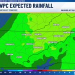




Flip it and reverse it, as Missy Elliott would say. Anyways, Forecast models have considerably backed off the idea of a decent soaking rain this weekend, with some now suggesting we may see nothing at all. However, most still keep some light rain in the forecast for Sunday morning.
Rainfall totals have dropped to a quarter of an inch or less, with amounts decreasing the farther north you go.
That's good news for Halloween weekend plans, but not so great for our worsening dry conditions. Our next chance for rain may not come until late next week, and with drought conditions developing and rainfall deficits continuing to grow, we could really use a good soaking.


Nothing spooky in the forecast for the next 4 days, but that could change as we head into the weekend. Models are having a hard time figuring out exactly when our next batch of rain moves in. Some bring it in Saturday afternoon, while others hold off until Sunday morning, which currently looks the most likely. Either way, it should be a good soaking rain.


I need to vent. I'm so sick of people hyping up this super El Niño like it's going to bring the snow apocalypse 3000. The first half of winter looks like a womp womp, second half might have better snow odds based on climate history, but holy cow it's driving me insane. I get the weather is boring right now and these YouTubers needs clicks for money but please find something else for a day 😩
HALLOWEEN: For the most part it will be nice with highs in the mid to upper 70s. Low chance of rain but it doesn't appear to affect the trick or treat activities. With it being 6 days away, this could change a little.

Good question! PLEASE know this before we start talking about snow. Northern Valley (Purple) is the Tri-Cities, Central (Pink) is around Knoxville, and Southern (Blue?) is around Chattanooga.
It's easier to group areas instead of naming them individually.


The Christmas Tree goes up...
20%November 1st
7%November 15th
70%After Thanksgiving
4%December 24th
142 votes • Final resultsThe story for the foreseeable future will be above normal temperatures as we go into November. Parts of the southern valley and maybe even the central valley will flirt with the 80s this week.
I would get used to this for at least the first half of winter.

A trough of low pressure several hundred miles east of Bermuda is producing disorganized showers and thunderstorms. Further development is not expected as it moves north-northeast into unfavorable conditions. Formation chance is near 0% through 48 hours and 7 days.

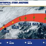
Post-Tropical Cyclone Josephine is about 235 miles east-southeast of Nantucket Massachusetts. Winds 65 mph. Josephine becomes a powerful extratropical low. A gradual turn toward the east is forecast on Friday and into the weekend. Moving northeast at 17 mph.

The latest drought monitor is out, and roughly half of our area is now considered abnormally dry, with some spots experiencing moderate drought conditions. Unfortunately, conditions will likely worsen over the next week, with little to no rain expected until late next week at the earliest. If winds were stronger, fire weather concerns would be a much bigger issue right now.

Subtropical Storm Josephine is about 200 miles southeast of Nantucket Massachusetts. Winds 65 mph. Josephine moving northeastward across the northwestern atlantic. Expected to become a powerful extratropical cyclone this afternoon or tonight. Moving northeast at 12 mph.

Subtropical Storm Josephine is about 195 miles south-southeast of Nantucket Massachusetts. Winds 65 mph. Josephine accelerating northeastward away from the united states. Expected to become a powerful extratropical cyclone. Moving northeast at 13 mph. As of Oct 22 at 5:00 AM EDT.

Subtropical Storm Josephine is about 245 miles south of Nantucket Massachusetts. Winds 65 mph. Josephine expected to move northeastward away from the united states on thursday. Forecast to become a powerful extratropical cyclone. Moving north-northeast at 6 mph.

This will be really cool. Instead of individual warnings being issued for a storm, the polygon will follow the storm so everyone gets equal warning times.

It’s been in development a long time, but finally, “threats-in-motion” likely to come in 2028 as new software is implemented across the National Weather Service. Severe storm warnings will move with the storm. @nwas
Picture perfect football weather is on tap Saturday as Tennessee travels to South Carolina. Expect highs in Columbia to reach the upper 60s with light winds around 5–10 MPH.

Disorganized showers and thunderstorms near Bermuda have a 10% chance to form in 48 hours and 10% in 7 days, then upper-level winds should limit development by the weekend. Subtropical Storm Josephine is offshore the Mid-Atlantic coast.

