

One Life One Chance. Loves Rain than everything else. Tweets on cricket, chess and anything, etc.
Chennai, India
Joined October 2014
- Tweets16.4K
- Following429
- Followers57K
- Likes2.6K





Pinned Tweet
Northeast Monsoon (NEM) rainfall not exactly an outlook, just a glimpse what can be expected in 2026.
-----------------------
El Niño is an important factor, but it does not determine the outcome of the Northeast Monsoon. The monsoon has its own way of unfolding, often throwing surprises and reminding us that every season has a story of its own
For reference, the seasonal NEM rainfall normal is 855 mm for Chennai and 445 mm for Tamil Nadu. Interestingly, historical comparisons suggest that around 85–90% of El Niño years have recorded above normal NEM rainfall. This is a historical tendency, not a guarantee of what any particular year will deliver.
A look back at some remarkable years
-------------
2015: Chennai recorded around 1,664 mm during the Northeast Monsoon, a season remembered for its catastrophic floods.
1997: Tamil Nadu recorded around 810 mm, setting a remarkable rainfall record that surpassed the previous benchmark from 1946.
1982: A contrasting year, with significant rainfall deficits across Chennai and Tamil Nadu.
One striking aspect of 1997 and 2015 is that their extraordinary rainfall outcomes were not simply a consequence of frequent cyclone activity. In particular, 1997 stands out for the scale of rainfall recorded across Tamil Nadu despite the relative lack of cyclonic activity.
What about the 2026 Northeast Monsoon?
-------------------------
The 2026 Pacific sea-surface temperature pattern shows a strong warm signal along the equatorial Pacific, consistent with El Niño conditions. However, history reminds us that we cannot assess the Northeast Monsoon by looking at El Niño alone.
The Indian Ocean Dipole (IOD) is another important player, influencing the broader ocean-atmosphere environment. And then comes the kingmaker the Madden–Julian Oscillation (MJO).
King maker MJO
--------------
The MJO's presence over our basin during the past week is encouraging and we can see the Tamil Nadu rains this october from negative to positive with MJO's help . If it remains favourable and spends a meaningful amount of time over the Indian Ocean during November, it could support active spells of convection and rainfall over Tamil Nadu. Its movement and persistence will be crucial factors to watch.
My rainfall outlook for 2026
-----------------------------
Tamil Nadu: The season has the potential to finish above normal, possibly in the 470–520 mm range, compared with the normal of 445 mm.
Chennai (KTCC): Against a normal of 855 mm, the city has received approximately 230 mm so far. The coming days could help push the seasonal total towards or beyond 300 mm, depending on how the last week Low pressure play out, if it goes to North Andhra / Odisha, we might miss crucial spells.
1. Tamil Nadu, I do not expect 2026 to match the extraordinary rainfall totals of 2015, let alone approach the 1997 benchmark of 810 mm. A finish closer to 500 mm looks like a reasonable possibility at this stage.
2. KTCC (Chennai), however, the story could be different. A few intense, well-positioned rainfall events can dramatically change the seasonal tally. Crossing 1,000 mm is possible, although it would require favourable conditions to persist and some significant rainfall spells. Reaching the exceptional levels of 1,500 mm or more recorded in years such as 2015 and 1997 would be a much bigger challenge.
3. . South Tamil Nadu — El Niño years, South TN oda attam vera level!. Districts such as Kanyakumari, Tirunelveli, Theni, Tenkasi, Virudhunagar, Thoothukudi, Madurai and Ramanathapuram can perform very well during El Niño years, with several areas having the potential to record high excess rainfall. South Tamil Nadu is one of the regions I am optimistic about this season.
4.. West Tamil Nadu — The Kongu belt's only concern. Districts such as Coimbatore, the Nilgiris and other parts of the Kongu belt depend significantly on low-pressure areas and upper-air cyclonic circulations (UACs) moving from the Bay of Bengal across the peninsula towards the Arabian Sea. These systems can bring very good rainfall to the western districts. So watchout for +IOD which can lead to more systems in Arabian sea, which can help easterlies to Kongu belt. This region remains my main area of concern. However, years such as 1997 showed that the Kongu belt can perform exceptionally well. These districts have already started October with a bang, and I expect them to do well during the October 20–24 spell. Normal to slightly above-normal rainfall is a reasonable expectation for this region.
5. Interior Tamil Nadu — Many UACs could make the difference. From Salem, Dharmapuri, Krishnagiri and Tirupattur to Vellore, Kallakurichi, Tiruvannamalai and other interior districts, rainfall often depends on the formation and movement of upper-air cyclonic circulations or weak ciruclations. Such systems are not uncommon during El Niño years. These districts, along with the Kongu belt, bore the brunt of hot spells and relatively poor rainfall during the Southwest Monsoon. However, the Northeast Monsoon offers a fresh opportunity. I expect most of these interior districts to receive normal to above-normal rainfall during NEM 2026, provided favourable circulations develop.
6. Delta and Cuddalore–Puducherry belt — The wettest zone of NEM!. From Cuddalore through the Delta districts towards Puducherry, this belt is among the most favoured regions during the Northeast Monsoon. No major surprises here I expect this region to perform very well, with the potential for at least 20% excess rainfall over the seasonal normal.
The Northeast Monsoon still has a long way to go. November, in particular, could be decisive. November forecast is looking good. As always, these are my current expectations based on the evolving climate and weather pattern, not a certainty as always NEM throws few surprises along the way and rains tell their own story.

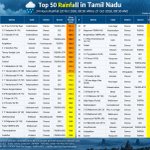
Tamil Nadu Top 50 Rainfall in 24 hrs ending 8.30 am of 22.10.2026 - Kanyakumari, Thenkasi, Thoothukudi, Tirunelveli, Tiruvannamalai all got widespread heavy rains.
KTCC (Chennai) Top 50 Rainfall in 24 hrs ending 8.30 am of 22.10.2026 - ECR areas around Mahabalipuram and Areas in Tiruvallur around Ponneri bely got heavy rains. City got moderate harmless rains around 20-40 mm rainfall.


Chennai Water Supply Lakes as on 22.10.2026 - Good inflow continues in to Puzhal while good rains in Poondi and Thervoy Kandigai. Today more rains expected in Lake Catchment areas.
Please see Today Oct 22 Forecast posted earlier - facebook.com/share/p/1K1cYmJ…
Seesaw effect on Oct 23-25 - facebook.com/share/p/1CDwjfr…

October 23-25 - Seesaw effect, Interior Tamil Nadu including Northern districts will join the rain party. KTCC (Chennai) falls perfectly in middle of the seesaw game played by systems on both Arabian Sea and Bay of Bengal.
Overall next 3 days looks damn good for overall Tamil Nadu, while Chennai as usual will get more than its share.
Please refer October 22nd forecast in earlier post -facebook.com/share/p/1JKMyQR…


South and West Tamil Nadu are likely to be the major hotspots, with heavy to very heavy rainfall expected in several districts.
======================
South Tamil Nadu – Major Hotspots
---------------
With the low-pressure area lying over the Gulf of Mannar, Kanyakumari, Thoothukudi, Tirunelveli and Tenkasi districts are likely to witness heavy to very heavy rainfall.
Other southern districts, including Virudhunagar, Madurai, Ramanathapuram and Theni, can also expect good rainfall.
Western Tamil Nadu
-----------------
Dindigul, Coimbatore, Tiruppur, the Nilgiris, Karur and adjoining districts may also receive good rainfall as the system moves towards the Arabian Sea tomorrow.
Across Tamil Nadu all districts
-------------------------
From the interior districts to the coastal belt, rainfall is expected across much of the state. The interiors are also likely to get their share of rains.
Chennai and Surrounding Areas - Day rains possible from today
--------------------
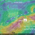
As seen in the image, when a low-pressure area lies over the Gulf of Mannar, it can pull easterly winds and rain-bearing clouds well into the interior regions. Not only Chennai, Vellore, Ranipet and the catchment areas can also receive rainfall. Even during the daytime, sudden, short-duration intense spells are possible in Chennai.
Watchout for Coonoor, Majolai belt for extreme rains.

Tamil Nadu Observed 24 hrs Rainfall as on 21.10.2026. Chennai dominated the TN charts. Kanyakumari and Coimbatore also got very good rains.

KTCC (Chennai) Rain Update for next 24 hours.
----------------------------
As we move into the daytime, rainfall activity is expected to ease across Chennai as the rain bands have shifted north towards the Ponneri–Pulicat belt.
The sun may come out during the day, with isolated spells of rain still possible. However, rainfall activity is expected to pick up again from tonight through tomorrow morning.
The intensity is unlikely to match last night’s spell. Moderate to heavy rainfall is possible during the night and early morning hours.
For other districts, a separate post would be put up.

Chennai Water Supply Lake Position as on 21.10.2026 - 5 tmc crossed, good inflow continue in Puzhal being close to city. we need more rains in catchment. Next 3 days there will be some rains and inflows will be sustained.

KTCC (Chennai) Rain update - Intense rain bearing clouds are moving into Chennai now. Rain rates are expected to increase across the city as this spell moves in.
The timing coincides with people returning to Chennai from their hometowns after the holidays.
Pa group ku nalla news varuma ?

Centuries in KTCC (Chennai) and it tops the rainfall charts of Tamil Nadu once again. More rain clouds moving into Chennai.
Before 8.30 am many more places in Chennai will cross 100 mm and we might see them ending between 100-150 mm by 8.30 am when rainfall recording resets.


Coastal belts like Chennai seeing clouds slowly building up and moving in. As we go into night more clouds should converge.
West TN Coimbatore belt superb rains
South TN - Thoothukudi, Thenkasi, Theni, Thoothukudi, all getting rains.

Good Spell starts in Anna Nagar-Koyembedu belt ? Anywhere else rains have started in the City ?
As we go into night to morning, the rains intensity will pickup and cover all city areas.
Forecast for 20.10.2026 to morning of 21.10.2026 - One of the best days for Coastal belts tonight to tomorrow morning. Chennai also falls in the hotspot zone.
=================
Systems in play in Indian Ocean (1st image) - You can see the UAC near Sri Lanka bringing the convergence over TN coastal and nearby districts. This will cross inland and move to Arabian Sea via Kerala. After that south TN time to enjoy rains.
Chennai (KTCC) from today. Expect sudden, short and intense spells of rain during the daytime, followed by sunny breaks. Rain intensity is likely to increase from evening into the night and continue through the early morning hours.
Delta, Pondy, Cuddalore Villupuram coast all will get very good rains. Ramnathapuram coastal areas, Pudukottai coastal areas will also be in hot spot today tonight to tomorrow morning.
Other districts close to coast like Thanjavur, Perambalur, Ariyalur, Cuddalore interiors, Tiruvannamalai, Madurai, Sivagangai, Thoothukudi, Thenkasi, Theni, Virudhunagar, Trichy all will get rains


Beautiful !!!

#WATCH | ஏனோ வானிலை மாறுதே...! சென்னை கோயம்பேட்டை சூழ்ந்த கருமேகங்கள்
#keyambedu #rainclouds #News18TamilNadu
The UAC is going to cross from Bay of Bengal and move towards Arabian sea. This wind pattern is always favorable for rains for entire Tamil Nadu. South Tamil Nadu will be in hotspot. Even Kongu belt of Coimbatore. Tiruppur and Nilgiris will get moisture flow and get widespread rains in coming days.

அடுத்த 4 நாட்கள் புயல் உறுதி?
#5gtamilmozhi #tamilnadugovernment #rainfall #heavyrainyseason #chennai