

Research Fellow @EOS_SG Remote Sensing Lab / Dare to dream and think big
Singapore
Joined August 2018
- Tweets210
- Following232
- Followers368
- Likes800




Zhangfeng Ma retweeted

China Earthquake Administration reported the surface rupture of the 2026 Tibet Naqu earthquake. weixin.qq.com/sph/AWTAalymhN
Zhangfeng Ma retweeted

熊本県八代市で貴重な稲刈りをドローンで撮影しました。天災にも負けず稲穂は黄金色に実っており、たくましさを感じさせます。また俯瞰で見てみると、日奈久断層帯は民家の向こう側まで走っているのが分かります。


7月28日の熊本地震で、断層が地表に出現する一部始終の映像が撮影された熊本県八代市の水田で稲刈りがありました。地質学の研究者らが協力し、断面を痛めないよう鎌で手刈りを進めると、地表の断層がくっきりと姿を現しました。
写真特集mainichi.jp/graphs/20261003/…

Zhangfeng Ma retweeted

Wei Liu, Yijian Zhou, Han Yue; Fault Damage Zones Q Value Determination From Spectra Decay Analysis and Its Application to the 2019 Ridgecrest Aftershock Sequence. Seismological Research Letters 2026; doi: doi.org/10.1785/0220250403
Zhangfeng Ma retweeted

Finally out!
link.springer.com/book/10.10…


Zhangfeng Ma retweeted

熊本県八代市内で断層破壊の瞬間を捉えたThreads投稿動画から、相対地表変位を解析しました。カメラ自体の振動や手ブレを除去し、分かりやすい滑り履歴関数が得られています。水平変位には、昨年のミャンマー地震の映像解析結果よりも明瞭なオーバーシュートが見られます。
threads.com/@m.m.s.k.a.ao_ma…

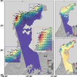
A first look at our joint inversion of the 2026 Mw 6.8 Kumamoto earthquake. The exceptionally high-quality ALOS-2/4 multi-view SAR observations provide dense constraints on the full 3-D coseismic deformation field, while the KiK-net strong-motion records offer excellent waveform coverage across Kyushu. Combining these complementary geodetic and seismic datasets reveals a remarkably shallow and spatially narrow slip zone, with the largest slip concentrated within only a few kilometers of the surface and limited along-strike extent. A nice example of how next-generation SAR together with dense strong-motion networks can resolve earthquake rupture in unusual detail.
#Earthquake #ALOS4 #ALOS2 #InSAR #KiKnet #Geodesy #Seismology


Zhangfeng Ma retweeted

地震前後の航空レーザ計測データを用いて、当社オリジナル技術であるICP法による地形変化解析を行いました。#令和8年熊本地震
ajiko.co.jp/disaster/1814
弊社技術が、現地の詳細解明ならびに二次災害の抑制に少しでもお役に立てば幸いです。

Zhangfeng Ma retweeted

だいち2号及びだいち4号の合成開口レーダー(SAR)データを用いて得られた令和8年熊本地震に伴う地殻変動データから、地表変位が不連続になる境界(変位境界)を判読しました。
gsi.go.jp/uchusokuchi/uchuso…

Zhangfeng Ma retweeted
令和8年熊本地震について、SAR干渉解析結果を追加しました。
2.5次元解析結果では、日奈久断層帯の北西部で最大約1mの東向きの変動、最大約50cmの沈降が見られます。
▼詳細はこちら
gsi.go.jp/BOUSAI/20260728_ku…

Zhangfeng Ma retweeted

Surface rupture locations are clear from ALOS-2 pixel offset results, some of them deviated from the know fault locations.
#KumamotoEQ #ALOS2


Zhangfeng Ma retweeted

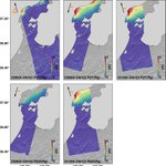
強震波形を用いた震源インバージョンについて、防災科研の推定と京大防災研の推定が公開されていました。
震源から断層浅部に向かって破壊が進展した後、断層両端に向かってバイラテラルに伝播したという大局的な滑り分布は変わりませんが、滑り量自体にかなり大きな差がありますね。

ALT 地震調査委員会 令和8年熊本地震の評価(令和8年7月29日公表) https://www.static.jishin.go.jp/resource/monthly/2026/20260728_kumamoto_1.pdf

ALT 令和8年熊本地震の評価(令和8年7月29日公表)

ALT 令和8年熊本地震の評価(令和8年7月29日公表)

ALT 令和8年熊本地震の評価(令和8年7月29日公表)

Zhangfeng Ma retweeted

昨夜のALOS-2 による熊本観測、思い出したんだけど2016年熊本地震でも観測をしていた。で、地理院地図で比較してみたんだけど、前回は断層の南側が大きく動いていて、今回は北側が大きく動いているように見える。 どういうことなんだろう?maps.gsi.go.jp/#11/32.646891… @gsi_cyberjapanより


Zhangfeng Ma retweeted
令和8年(2026年)熊本地震に関する情報を公開しました。
以下の内容を公開しています。
速報的な解析(16時36分時点)の結果、電子基準点「千丁」で北東に約84cmの地殻変動が観測されました。
・令和8年熊本地震に伴う地殻変動(暫定・速報値)
▼詳しくはこちら gsi.go.jp/BOUSAI/20260728_ku…


Zhangfeng Ma retweeted

Nuevos datos de la NASA:
Los sismos desplazaron Venezuela 🇻🇪 hacia el Oeste en algunos puntos hasta 60 centímetros.
➡️El 24 de junio de 2026, un terremoto de magnitud 7,2 sacudió el norte de Venezuela, seguido menos de un minuto después por otro sismo aún más intenso de magnitud 7,5. En conjunto, ambos sismos causaron enormes daños y pérdidas humanas en toda la región.
🛰️En los días posteriores, los mapas satelitales de desplazamiento del terreno revelaron cómo se movió la superficie terrestre.
➡️El desplazamiento fue especialmente intenso cerca de Caracas y La Guaira, Venezuela. El mapa se elaboró a partir de datos NISAR (radar de apertura sintética de la NASA-ISRO) adquiridos el 25 y el 30 de junio (después de los terremotos) y el 13 y el 18 de junio (antes de los terremotos).
🗺️MAPA: Las áreas blancas indican un desplazamiento de tierra mínimo o nulo. La falla es parte de una red de fracturas que se extiende a lo largo del límite entre la placa del Caribe al norte y la placa sudamericana al sur.
La ruptura de la falla se propagó mar adentro, hacia el este, y luego regresó a tierra firme cerca del aeropuerto internacional al norte de Caracas, marcada por la estrecha banda blanca visible entre el desplazamiento hacia el oeste y hacia el este. Justo al sur de esta sección de la falla, el color azul oscuro indica que el desplazamiento de la superficie hacia el oeste a lo largo de esta parte de la falla fue mucho mayor que en otras zonas, alcanzando hasta 60 centímetros.
#TerremotoVenezuela #NASA #SismosVenezuela #Venezuela #NISAR

Zhangfeng Ma retweeted

Updated slip model obtained using regional seismological data alone (stations in Colombia, the Caribbean, etc.) for the Venezuela earthquake of June 24, 2026, considered here as a single event.
More text detail on Linkedin : linkedin.com/feed/update/urn…

Zhangfeng Ma retweeted
We hire ERI postdocs. The application is due 4 September.
eri.u-tokyo.ac.jp/wp-content…
Zhangfeng Ma retweeted

Ascending & descending Sentinel-1 interferograms of the M7.5 Venezuela earthquake. Coseismic deformation truncates at the coast, exposing only the onshore half of the field, consistent with onshore nucleation in the west and eastward, offshore rupture propagation. #InSAR


