

Nature (weather)
Noorwegen
Joined February 2017
- Tweets60.4K
- Following242
- Followers17.8K
- Likes49.1K






Pinned Tweet
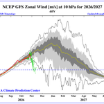
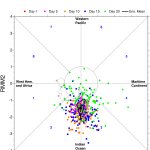
if you like you can check #denniswinterindex on the most actual ideas to #winter for west #Europe but i watch also closely to other parts
more is starting from 1nov
#ssw event happens 2-4 nov
ive made a own index on diff paramaters and its a test to see how things workout


AllNature retweeted

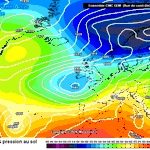
Strong blocking high pressure is developing over the UK and Ireland, this will trigger a major change in Europe's weather, especially for the central and eastern regions. Stay tuned.


AllNature retweeted

Un anticyclone à 1040 hPa en vue !
Patate anticyclonique encore plus puissante début novembre sur le nord-ouest de l'Europe selon les différents scénarios météo.
Résultat, l'EFI* réagit fortement pour débuter le mois prochain, un niveau exceptionnel pour la saison.
AllNature retweeted

Just an impressive Ural/Eastern Scandinavian block right there.
It's all connected to the Polar Vortex, with the Wave 2 pattern mainly responsible for the upcoming weakening event.
It's IMPACTS on the Eastern US, well we cant be totally sure about it, BUT...


AllNature retweeted

Medium-range models reaching toward middle November with powerful northeast Pacific trough and stretched PNA ridge preventing cold air access to Canada and U.S.


AllNature retweeted

𝐂𝐨𝐮𝐥𝐝 𝐭𝐡𝐞 𝐀𝐫𝐜𝐭𝐢𝐜 𝐬𝐭𝐫𝐚𝐭𝐨𝐬𝐩𝐡𝐞𝐫𝐢𝐜 𝐩𝐨𝐥𝐚𝐫 𝐯𝐨𝐫𝐭𝐞𝐱 𝐮𝐧𝐝𝐞𝐫𝐠𝐨 𝐢𝐭𝐬 𝐞𝐚𝐫𝐥𝐢𝐞𝐬𝐭 𝐦𝐚𝐣𝐨𝐫 𝐬𝐮𝐝𝐝𝐞𝐧 𝐬𝐭𝐫𝐚𝐭𝐨𝐬𝐩𝐡𝐞𝐫𝐢𝐜 𝐰𝐚𝐫𝐦𝐢𝐧𝐠 (𝐒𝐒𝐖) 𝐬𝐢𝐧𝐜𝐞 1958 𝐢𝐧 𝐞𝐚𝐫𝐥𝐲 𝐍𝐨𝐯𝐞𝐦𝐛𝐞𝐫?
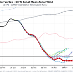
The latest numerical weather prediction guidance, available through the World Climate Service climate index feed as of October 28, shows substantial weakening of the zonal-mean zonal wind at 10 hPa and 60°N (U10/60°N), with multiple models forecasting a reversal from westerly to easterly winds in early November.
𝐖𝐡𝐚𝐭 𝐝𝐨 𝐭𝐡𝐞 𝐥𝐚𝐭𝐞𝐬𝐭 𝐟𝐨𝐫𝐞𝐜𝐚𝐬𝐭𝐬 𝐬𝐡𝐨𝐰?
• 𝐄𝐧𝐬𝐞𝐦𝐛𝐥𝐞 𝐠𝐮𝐢𝐝𝐚𝐧𝐜𝐞:: Across seven ensemble forecast models, 60.8% to 82.4% of members forecast U10/60°N below 0 m/s on at least one day during their respective forecast periods. The largest daily percentages generally occur between November 4 and 11.
• 𝐃𝐞𝐭𝐞𝐫𝐦𝐢𝐧𝐢𝐬𝐭𝐢𝐜 𝐠𝐮𝐢𝐝𝐚𝐧𝐜𝐞: The latest ECMWF high-resolution, GFS, and CMC forecasts also predict a reversal to easterly winds.
• 𝐅𝐨𝐫𝐞𝐜𝐚𝐬𝐭 𝐞𝐯𝐨𝐥𝐮𝐭𝐢𝐨𝐧: Successive GEFS Extended runs have shifted toward substantially weaker U10/60°N values. The October 27 00Z ensemble-mean forecast falls below the historical ERA5 record minimum for several corresponding calendar dates.
𝐖𝐡𝐲 𝐢𝐬 𝐭𝐡𝐞 𝐭𝐢𝐦𝐢𝐧𝐠 𝐬𝐢𝐠𝐧𝐢𝐟𝐢𝐜𝐚𝐧𝐭?
The earliest major SSWs in the ERA5 record since 1958 occurred on November 28 in 1968 and 2025.
Under the commonly used wind-based definition, a reversal of the observed daily-mean zonal-mean zonal wind at 10 hPa and 60°N from westerly to easterly during November–March is the principal criterion for identifying a major SSW, subject to additional event-classification criteria.
#PolarVortex #SSW #Stratosphere #EnergyMeteorology #Meteorology #Energy


