

Professional Storm Chaser Business Inquiries 👉[email protected]
Iuka, Ms
Joined March 2022
- Tweets6.6K
- Following412
- Followers872
- Likes6.9K




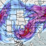


best chance at a strong cellular tornado will be in the late afternoon window just ahead of the dryline cluster in a zone of ows confluence.
As storms attempt to mature in the mean flow, stronger synoptic forcing for ascent should arrive, allowing these cells to attempt to peak and produce before the stronger low level shear out runs the warm sector.
Any surface based mesocyclones able to ride the stronger llj may persist into the evening as saturated profiles up to 700 mb allow for maintenance moisture to continue feeding into vigorous updrafts despite waning instability.
This case is the classic second season dynamic pressure falls > instability case.


Adrian Ronca-Hohn retweeted

43-42 win against North Pontotoc
22 Rushes for 210 yards 4 tds
Passing-160 yards for 2 tds
Game winning throw
hudl.com/v/2UXxdj

Monday…. A forecast discussion.
It’s fairly apparent at this point that a legitimate severe weather risk is set to unload into the southern Great Plains.
The first thing that caught my attention looking at latest guidance is the warm up shortwave ejecting just how you want it 18-24 before your event. This shortwave pulls moisture up into your target and allows further advection the day of to only deepen the quality of the moisture return. This is essential in cold season events.
The second glaring red flag is the obvious signal for prefrontal confluence out ahead of the dryline before the main speed max pivots in during the evening. All my box’s for open warm sector initiation is checked with broad diffluence at 300, heights falling consistently through the evening with the approaching glancing blow of the speed max, and backing at the surface with multiple perturbations south of a strengthening low.
Bulk shear is both strong and perpendicular along the dryline and the confluence axis. Beans should have a long window as the brunt of the forcing lags behind in the late afternoon. The question is, how will the enviorment sustain and grow storms in the mid afternoon before the speed max arrives, sandblasting the forcing into linear damaging wind segments. I have a suspicion lapse rates and low level instability are being under forecast by globals.
If you translate this exact same set up to Mississippi, it’s the classic 10# debacle. I think it’s a must be there for a early season jump on tornado counts. Good luck!


