








Sonny retweeted

Sunday Evening Video Discussion on the potential for a storm to develop later in the week. Video is about 14 mins and discusses the uncertainties, the synoptic background and the key things to watch on the models as we go through the week.
This video is not a forecast and does not go into immense detail of which locations are likely to see what strength winds. That detail will come later.
youtu.be/wgo4WSeQWv0

Sonny retweeted

Reform UK has launched Small Boat Watch.
Download the app now to see how many boats are crossing the Channel in real time, where they’re coming from, and how much it’s costing you.
👉 reformparty.uk/app/boatwatch

Well, the ECMWF is forecasting a rather shocking early storm system hitting the uk next Tuesday- Wednesday.
Maybe Storm Austen is arriving sooner than we thought…
Keep in mind things can change and this could become more severe than shown or less severe, or amount to nothing.


Sonny retweeted

Convective outlook has been updated ⛈️
Valid: Now - Thursday 21:59
A high risk has been issued across many parts of Midlands.
See dicussion in handry-outlook.github.io/Thu…


Convective outlook has been updated ⛈️
Valid: Now - Thursday 21:59
A high risk has been issued.
See dicussion in handry-outlook.github.io/Thu…

Sonny retweeted
Convective outlook has been updated ⛈️
Valid: Now - Thursday 21:59
A high risk has been issued.
See dicussion in handry-outlook.github.io/Thu…
Convective outlook has been issued ⛈️
Valid: Tonight 22:00 - Thursday 21:59
A very complex setup.
A detailed discussion will be published later tonight, and a high risk will be issued if confidence increases later.
handry-outlook.github.io/Thu…

Sonny retweeted

(Thu) Outlook Issued👇(Low confidence)
A strong band of thunderstorms will move NNW up the country in the morning with the risk of hail, lightning and flash flooding. I have issued a Sig 2 severe which is mainly flooding based but it means moderate flash flooding and hail possible. Please take care when driving and keep up to date with Met Office warnings.
This set up is still low confidence but a High risk maybe used if confidence grows.

Sonny retweeted
Convective outlook has been issued ⛈️
Valid: Tonight 22:00 - Thursday 21:59
A very complex setup.
A detailed discussion will be published later tonight, and a high risk will be issued if confidence increases later.
handry-outlook.github.io/Thu…
Currently the models are just not making their damn minds up, and I am just starting meteorology so I am really not good with this sort of thing yet. I was gonna issue my first outlook but not anymore unfortunately . Sorry
Sonny retweeted
Pretty good verification so far given the uncertainty although storms didnt extend as far south as I thought but i am happy with this
Thursdays outlook will be issued before 20:00

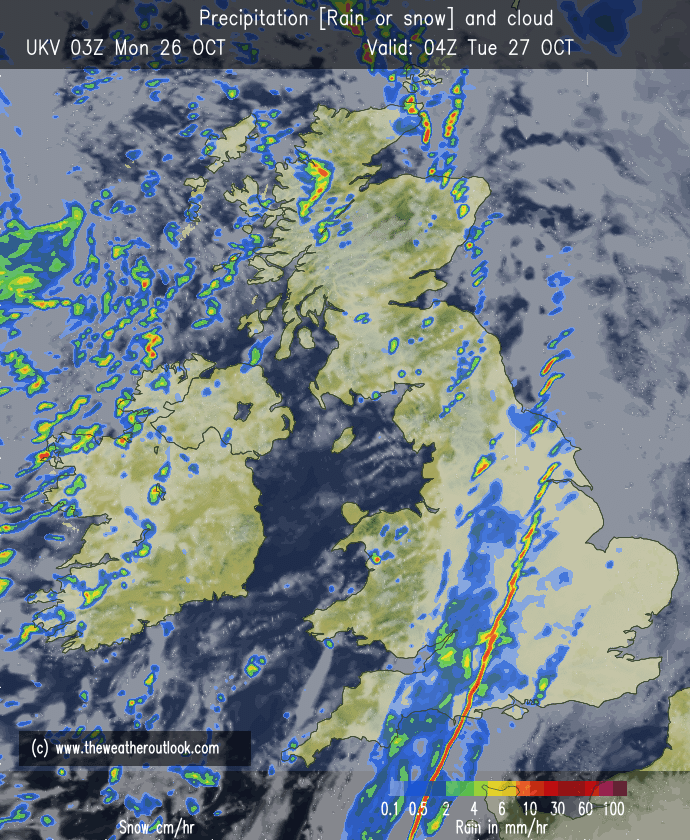
Also, just wanted to inform you guys that tonight and overnight in the south coast of the uk, there is the potential for very heavy rain and thunderstorms which many models agree with, such as the UKV which I will show below.
Sonny retweeted

Finalised Convective Outlook for Wednesday:
Strong thunderstorms are expected to break out across the British Isles. I’ve already covered the details in my previous outlook, so refer to that for the full breakdown.
I’ve upgraded the Southern & Western Ireland threat and made adjustments to several other risk areas based on the latest guidance.


Updated Outlook:
Strong thunderstorms are expected through Wednesday, with the first round developing during the early morning hours before tracking northwards across eastern parts of the UK. Frequent lightning, large hail, strong gusty winds and surface water flooding will all be possible.
During the afternoon, scattered to isolated thunderstorms are expected across Southern England, the Midlands and potentially northern areas. These will be hit-and-miss in nature, but a few could become locally severe, bringing frequent to perhaps very frequent lightning, large hail, strong gusty winds and intense rainfall. Isolated flash flooding will also be possible.
As storms track northwards, rainfall totals of 20–30mm in one hour and locally 40–50mm in 2–3 hours are possible. With some areas still experiencing very dry soils following the drought, there will be an enhanced risk of surface water flooding and isolated flash flooding.
This will remain a low-end Moderate risk for the event, with moderate confidence. No upgrades are currently expected, although slight adjustments to the outlook may be made shortly before the event.


