

🇺🇸 East Texas Native • Meteorologist • Lindale Eagle | TJC Apache | SFA Lumberjack | MSU Bulldog • FB & Instagram: Doc Deason Weather
Tyler, TX
Joined September 2009
- Tweets42.4K
- Following3.7K
- Followers4K
- Likes16.3K

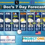


FRIDAY MORNING WEATHER
(Powered By: Rose City Air & Altra Federal Credit Union - Texas & Halbert Home Services)
Good morning and welcome to the last Friday of October! While this month has flown by, it has done so on a much slower clip insofar as cooling temps are concerned compared to normal. Still, we have managed to make some decent progress, at least when you look at where we were at the start of the month.
• We’re covered in clouds again to start the day as Pacific moisture streams over the region from the southwest. This trend will continue through the day as the lift also slowly encroaches on the state from Mexico.
• Radar would argue that we’ve got some decent rain beneath these clouds as far east as I-35 this morning, too, but the observations aren’t holding up that case. Still, I don’t think you can completely rule out a stray sprinkle across our western counties today, but it shouldn’t amount to much, regardless.
• Temps today will be a tougher call from west to east as some drier air helps to fight some of the clouds across the eastern half of the area. This will set up a bit of a temp gradient from east to west. Still, the amount of clouds will keep us cooler than we were on Thursday as a general rule.
• As the better lift approaches the area this evening, look for light rain and shower chances to increase, especially after midnight and as we get into the day on Saturday.
• As we’ve been talking about for several days, the totals we see from this event will not be all that impressive. And given the dry pattern we’ve been in, I would say they’ll be hard to recognize across the especially parched eastern half of the area, although they’ll be welcomed nonetheless.
• Look for scattered light rain and some showers to mix in off and on through the day on Saturday as the best lift crosses the area. Thunder will be hard to come by on Saturday, too, which also speaks to the weakness of the overall process and the lack of heavier downpours.
• Rainfall should be in the process of exiting east of the area by late Saturday afternoon. I’ll leave in a low-end chance of a stray pocket of light rain early that evening, but most folks should stay dry, and this will help to minimize impacts on trick-or-treaters as a result.
• Look for more clouds than sun on Sunday and Monday, although some peeks of sun will help to bring temps back up above the 80° mark both days as we build more moisture back into the area from the south.
• The main event of the forecast is the cold front that’ll push through the area probably earlier on Tuesday. It’ll be preceded by showers and thunderstorms and then breezy and clearing conditions pretty quickly thereafter.
• Given the time of day, we may be a bit more hard-pressed to see any severe weather across East Texas. That’s something which will come into better focus over the weekend and as we get closer to the front’s passage. I still think we’ll have some good rain to work with, though, which is important in and of itself.
• Drier and cooler air will move in behind that boundary, and we’ll set ourselves up for a really pleasant mid to latter part of the week with temps much closer to what you’d expect to see during the opening frames of November.
• Tropical Update: NHCs board is currently clear of any active systems of note or anything showing potential signs of it over the next seven days.
☀️ Today • Sunrise: 7:36 am - Sunset: 6:32- pm | Total Daylight: 10:55 (-1:45) ⎥ Tyler Normals: 52/74 – Records: 88°/2024 – 24°/1917 – 3.47”/1992
📊 Lower 48 Temp Extremes for Thursday: 93° at 17 miles east of Ochopee, Florida 🔹 13° at 19 miles southeast of Juntura & at 19 miles northeast of Kirk, Oregon.
• Thursday’s Climate Stats • Tyler City: 63/80 (0) -- Tyler Pounds: 63/80 (0) -- Longview: 59/84 (0) – Lufkin: 58/82 (0) #etxwx #txwx

Doc Deason retweeted

Red counties in Texas are slowly and steadily on track to almost unanimously clear their 2022 midterm turnout, some by 30% or more or up to presidential.
None of the big four blue counties appear to be on track to hit their presidential counts, which is where I factored them during my worst case analysis. Travis needs to hang 200k votes in the last two days of EV + ED to get there. And they had 103% of previous presidential turnout in 2018.
Talarico still on pace to lose 40k or more of O’Rourke margin in El Paso.

THURSDAY MORNING WEATHER
(Powered By: Rose City Air & Project One Roofing & Halbert Home Services)
Good morning and welcome to Thursday! Generally speaking, overall thinking about the next week or so really hasn’t changed much over the last 24 hours. We’re still looking a lot of the same features we’ve been talking about.
• Low clouds are trying to make progress northward again this morning, thanks to a bit more modest southerly fetch from 1,000-5,000’ off the surface. Most reporting stations are at or above where they were at the start of yesterday when it comes to temps, too.
• Besides the low clouds, we have additional high clouds that are going to continue streaming across the area today, thanks to the changing pattern aloft up at around 18,000’. As I mentioned last night, in spite of the added clouds, the slightly warmer start will still allow for temps to make another healthy move back above the 80° mark again today.
• Unfortunately, the clouds will not result in any significant rain chances for at least our area through the day today or even on Friday.
• By Friday night, though, especially as you get later, rain chances will begin to creep into the region from the west as our next storm feature moves out into the Plains while staying to our north. This will ultimately result in our best rain chances areawide during the day on Saturday. That said, with those better dynamics staying to our north, this will still hamper the rain processes across our area. So, while overall chances for rain area good for most of us, the overall totals are not looking all that impressive. So, I think that bears mentioning. Most folks will have well-under a quarter inch in their gauge by sundown on Halloween.
• Rainfall will ease to the east by Saturday night and that’ll be the start of another dry period through most of Monday.
• We will continue warm and progressively more humid following the exit of that first round of rain. So, those wanting a reprieve will have to wait a little longer as we remain well above normal throughout the weekend.
• As we’ve been talking about for several days, we have a much more organized system set to cross the country from Monday through mid-week and this one looks to be the catalyst for much better rainfall potential, including some heavier rain and maybe even some severe weather potential, depending on how things come together with timing of certain parameters for Tuesday. Regardless, the more widespread and soaking rain will be a big coup for the area.
• Even at this early stage, the Weather Prediction Center has already outlined much of the area inside of its “Marginal” flash flood outlook for Tuesday, which is always interesting to see. For some of us, it has been a mighty long time since you’ve had any rain of consequence. At least the western and central counties have had some luck over the past month or so. But, the eastern counties have really struggled in this department and I’m excited for those areas especially when it comes to this next week’s system.
• Ultimately, this will all culminate in the passage of a cold front that’ll help to usher in drier and cooler air for the mid to latter part of next week and at least get us closer to normal for the early part of November.
• Tropical Update: The tropics continue quiet throughout the Atlantic Basin at this time. Again, hurricane season will officially end on November 30th.
☀️ Today • Sunrise: 7:35 am - Sunset: 6:33 pm | Total Daylight: 10:57 (-1:46) ⎥ Tyler Normals: 52/74 – Records: 89°/2024 -- 24°/1910 – 2.08”/2000
📊 Lower 48 Temp Extremes for Wednesday: 93° at 7 miles east-southeast of Hidalgo🔹9° at Peter Sinks, Utah
• Wednesday Climate Stats • Tyler City: 60/84 (0) -- Tyler Pounds: 57/83 (0) -- Longview: 55/83 (0) – Lufkin: 57/85 (0) #etxwx #txwx

Doc Deason retweeted

Glenn Beck thinks that he knows why governments all over the world are suddenly encouraging their citizens to get prepared, and it isn't good news...
nitter.gq/glennbeck/status/21155…

The last time I felt the urge to give a warning like this was in 2007, right before the 2008 crash.
Across Europe, governments are quietly issuing emergency "Be Ready" advisories, asking citizens to stockpile cash, water, and food. Add that to the Pentagon’s new FORTRESS initiative and it sure looks like... SOMETHING is coming.
They're preparing for impact. And you should too.
I hope and pray I'm wrong. But I think massive global conflict is coming... and here's why.
🏆 Congratulations to the Milwaukee @Brewers! The team from the SMALLEST TV market in the entire league just 💣 every other small, medium, and major market team in the league. Incredibly satisfying and a great lesson. ⚾️ I’m so happy for their fans, which I’m one of now, too.
I hope the @Rangers were taking notes…
Doc Deason retweeted

Global life expectancy.
The first dip is Mao. The second dip is Fauci.
(Hat tip @mattwridley)
🤖 Made with AI


Doc Deason retweeted
🚨 Former FBI Deputy Director Dan Bongino is sounding the alarm as nations worldwide quietly stockpile essentials.
He’s telling families to lock down a preparedness plan, radios, water filtration, and emergency supplies today.
"Do it for your family". ⏳🇺🇸
Do it. It should never have been pulled in the first place. One look at that logo and you can tell it's very respectful.

Pretty sure everyone knows how I feel about this ❤️ HTTR4LIFE
@Commanders @NFL need to stop canceling Native Americans.
🚨Descendants of Chief John Two Guns Whitecalf, want the Washington Redskins logo restored. The fight is about much more than football. The Chief was a proud advocate for Native Americans and spent his life fighting for his people.
His likeness as the face of the Redskins was a symbol his descendants considered as an honor. Now, the family is fighting to get the logo back.
The Redskins logo was never a caricature or an insult for the family. It represented a real man whose story deserved to be remembered and now the family wants it back.
Do you think the NFL should restore the logo?

Yeah. Really well done!! Thanks, MLB.

INCREDIBLE 😮
20-year-old Julie Falcon with a stunning national anthem performance ahead of #WorldSeries Game 5 ⭐️
Doc Deason retweeted
🚨 9 litres of water. 3 days of food.
The UK government just launched the new "Be Ready" campaign urging every Briton to stock up on 72 hours of emergency supplies.
Why?
Is war coming, or is it something else?
💦 Looking ahead: While we do still have scattered showers in the mix for our area from late Friday night and off & on through the day on Saturday, the overwhelming majority of this next 6-7 days' worth of rain totals (shown here) will occur on Tuesday.
• That kind of production would argue for at least some stronger storm potential, too, although we're still way too far out to get very specific.
• Regardless, I think it's worth mentioning that our secondary severe weather season around these parts takes a move upward in November. #etxwx #txwx


Doc Deason retweeted

When NYC was NYC!

Doc Deason retweeted

Bring back incandescent bulbs!

Researchers gave office workers who lived under LEDs a 60W incandescent desk lamp. Two weeks later, every one of them had their color vision improve by 25%.
In 2022, the government banned those bulbs for "wasting" energy.
But that "waste" is actually one of the most important nutrients our bodies depend upon, and the improvement lasted for weeks after the lamps were taken away (while nothing changed in the controls).
Decades of forgotten research show the artificial light we replaced it with is a root cause of many inexplicable illnesses (e.g., insomnia, obesity, cancer, and hyperactivity in children).
Here I show what that research found and why Senator Mike Lee’s bill to bring these bulbs back, which has now cleared a Senate committee, matters.🧵
midwesterndoctor.com/p/the-h…

WEDNESDAY MORNING WEATHER
(Powered By: Rose City Air & Project One Roofing & Halbert Home Services)
Good Wednesday morning and welcome to hump-day! We’ve seen a pretty good increase in overall moisture content over the last 24 hours. You can see it in both precipitable water and the dew point.
• Last night, while I was trying to stay to the end of the World Series game that I thought would be the last of the series, that classic southerly fetch off the Gulf at about 5,000’ had already established itself, which is what helped the low clouds along that you’re seeing out there this morning. Some models picked up on it. Some did not.
• The clouds will hang in here for a while this morning before trying to scatter out. Still, with as warm as we are to start, temps should still make a decent run back into the low to mid 80s, and all of this will help to make it feel more on the humid side of the ledger.
• For whatever clearing we’re able to accomplish this afternoon, we’ll see another batch of low clouds get in here later tonight, again, and that’ll set the stage for another relative repeat performance of things on Thursday.
• By Friday, we should have more clouds to work with overall, and that would tend to argue for a little less in the way of heating, especially when you remove any residual ridging aloft which will have been further displaced by the approaching trough to our west and north.
• Shower chances should start to make their way into the area later on Friday night/early Saturday morning, and that’ll help to set the stage for what’ll be a cloudier day on Saturday. Showers and some occasional thunderstorms will continue in play on Saturday, but it will not be a continuous deluge throughout the day.
• Rainfall should exit the stage to the east on Saturday afternoon/early evening, and that’ll leave us generally dry for trick-or-treaters.
• Look for more clouds than sun again on Sunday, although we should see more than we will have seen for a few days which will give us a kick back up into the low-80s for highs after church. It’ll feel all kinds of weird on Sunday evening as the resumption of Standard Time plays havoc with the early onset of darkness that evening.
• Speaking of darkness, we’ll see more clouds get in here on Monday afternoon as our next storm feature quickly moves back through to our north. In the process, we should have a better environment for showers and thunderstorms thanks to the addition of a front and some overall nearer dynamics to work with in general. Questions are still there with some intermittent signs of what could be some kind of severe potential, but it’s too far out to start getting very specific. November means our secondary severe weather season has arrived and it should be understood that the potential will lurk more as we move ahead from here.
• We’ll see another decent cold front push through here at some point later Monday or Tuesday, like we’ve been talking about for a few days, which will help to bring drier and cooler air back into the region.
• Interesting climate note: Today marks the first sub-90° (89/1977) record high temperature at Tyler since April 15th...just another sign of Fall, y'all!
• Tropical Update: The tropics continue quiet throughout the Atlantic Basin at this time. Again, hurricane season will officially end on November 30th.
☀️ Today • Sunrise: 7:35 am - Sunset: 6:34 pm | Total Daylight: 10:59 (-1:47) ⎥ Tyler Normals: 52/74 – Records: 89°/1977 -- 27°/1957 – 2.29”/2022
📊 Lower 48 Temp Extremes for Tuesday: 91° at 7 miles east-southeast of Hidalgo🔹14° at Peter Sinks, Utah
• Tuesday Climate Stats • Tyler City: 57/82 (0) -- Tyler Pounds: 59/82 (0) -- Longview: 56/81 (0) – Lufkin: 57/78 (0) #etxwx #txwx


