

@GeoConfirmed
Account based inEurope
About this account
- Account based in
- Europe
- Connected via
- Europe Android App
Account-level information from X, not a live location or the device used for a specific post.
Map and Investigations = https://xitter.cf/t.co/B93nqcHOaM Managed by volunteers.
Joined March 2022
- Tweets33.1K
- Following289
- Followers23K
- Likes4.3K


Pinned Tweet
The State of the "X" OSINT Community,
a message to the 'OSINT' accounts.
Let’s all take a step back and look at the broader “OSINT” community, especially after Elon Musk’s changes.
What do we actually see?
Engagement Farmers.
The majority of these accounts claim to do OSINT and even include it in their name. But most of them don’t do the work. At best, they’re bad news aggregators — copying and pasting information without citing sources, rewriting descriptions to grab attention, and shaping opinions based on unverified data. They chase attention, not accuracy. In other words, they’re engagement farmers.
These accounts make up most of what’s now labeled as “OSINT.”
News aggregators.
Then there’s a second group — the news aggregators who at least add some value. They collect and organize information into threads or perform basic analyses that make data easier to understand. Importantly, they also give proper credit to the original sources. For them, it’s not about being the first to post — it’s about gathering reliable information and presenting it clearly and responsibly.
OSINT.
Finally, there are the 'real' OSINT accounts.
A definition: "OSINT is the practice of collecting, analyzing, and interpreting publicly available information from open sources to produce insights for decision-making, threat assessment, and investigations."
The real OSINT accounts go beyond aggregation.
They verify locations, identify equipment types, and perform full investigations — turning raw data into actionable, verified insights.
Mistakes.
And yes, even OSINT accounts make mistakes. Why?
Because OSINT is only as accurate as the information available at the time of analysis. That’s why verifying the basic data used in any analysis must always be a priority. Crediting sources is equally important — it allows others to understand the reasoning behind the analysis and, if necessary, to verify the same sources independently.
When new information emerges, earlier conclusions may turn out to be flawed. It’s then the responsibility of the OSINT account to evaluate whether the new data impacts the final assessment. If it does, the correct course of action is clear: delete the original post and start again. Deletion is the only acceptable response when an error alters the conclusion.
GeoConfirmed.
We know where we stand:
GeoConfirmed is a verification community of more than 100 volunteers, dedicated to answering factual “where” questions.
Does that make us an OSINT account? That’s not for us to decide.
In four years, GeoConfirmed has made seven mistakes — just seven. Each time, we reviewed our verification process, because seven out of more than 60,000 published geolocations is still seven too many.
That’s the level of responsibility our admin team has committed to. We guarantee where something happened — not what happened, and not when. With the exemption for our 'investigations' where we used the geolocation as a basis for a further analysis.
And in every one of those seven cases, we deleted our tweets and posted corrections.
How many accounts, even 'OSINT' accounts, get fact-based feedback, even Community Notes, but never make corrections? For them, it’s not about the facts. The initial tweet draws attention — and that’s what matters most to them.
How to handle mistakes.
Everyone can make mistakes. There is only one correct response to a mistake: delete the tweet and post a new one with the correction.
Let’s be very clear about this. Accounts that post a “correction” in a follow-up tweet are still benefiting from the attention generated by the original post. They aren’t prioritizing facts — they’re preserving engagement. The correction will never reach as many people as the original tweet, meaning the misinformation or disinformation continues to spread.
Deleting the mistaken tweet and reposting it with the correct information is the only responsible solution.
---
So, if you call yourself an OSINT account, ask yourself this:
Am I part of the third group? Am I doing what should be expected from an OSINT account?
If the answer is no, then you are not an OSINT account and shouldn’t present yourself as one. Unless you take concrete steps to meet the standards of real OSINT work, you’re not contributing to the field: you’re merely chasing attention under a false label. That doesn’t make you an OSINT account — it makes you a fraud, using OSINT for attention, and adding noise instead of value.
---
Pictured:
GeoConfirmed’s admin team verified geolocations conducted by the GeoConfirmed volunteer community, as well as contributions from other volunteers, related to the Ukraine–Russia conflict.
Over 50,000+ GeoConfirmed locations where events occured.
(geoconfirmed.org/ukraine)

GeoConfirmed conflictmap YEM.
An artillery strike, conducted by Ansar Allah forces, reportedly targeted a roadway near the Alameen grocery store in Taiz, according to residents.
13.579509, 44.008158
7H56H2H5+R7 Taizz, Yemen
GeoLocated by @tzalivia
Reported involved units:
Ansar Allah ▸ Yemen ▸ Militant/Terrorist factions
Geolocation:
xitter.cf/tzalivia/status/211254…
Location:
geoconfirmed.org/yemen/a3e54…
Sources:
xitter.cf/tzalivia/status/211254…
Visit our map: geoconfirmed.org/map/yemen

An artillery strike, conducted by the Houthis, targeted a roadway near the Alameen grocery store in 🇾🇪 Taiz, according to residents. The strike resulted in superficial and structural damage to nearby structures and a roadway, though the extent of the damage remains unclear.
A photo shared by a resident on social media appears to show the strike, according to a preliminary geolocation. The tall building in the picture is the Tadhamon Bank, identifiable by the side profile, distinctive dark blue and gold paint, and several other features, including a sign on the building declaring it as such.
The surroundings also fit the area described by residents as the strike location, including the presence of Jabal Sabir in the background. The geolocation is preliminary and thus subject to possible change.

Geolocation:
xitter.cf/tzalivia/status/211254…
Tadhamon Bank: 13.578117, 44.007422
Right Hill: 13.572217, 44.003158
Central Hill: 13.567281, 44.002500
Strike Location: 13.565422, 44.001964
@GeoConfirmed
Event via @ViditHQ: vidit.app/events/92085ea1-3f…

GeoConfirmed conflictmap YEM.
The drone unit in the Homeland Shield Forces managed to target a vehicle affiliated with the Ansar Allah forces, loaded with military supplies, in the Al-Waz'iyah front.
13.133665, 43.786252
7H554QMP+FG Dar Qashimiyah, Yemen
GeoLocated by @BobMilOSINT and @LoLManya
Geolocation:
xitter.cf/BobMilOSINT/status/211…
xitter.cf/LoLManya/status/211158…
Location:
geoconfirmed.org/yemen/c3092…
Sources:
xitter.cf/diralwatan/status/2111…
Visit our map: geoconfirmed.org/map/yemen

بعد رصدٍ دقيق، تمكّنت وحدة الطيران المسيّر في قوات درع الوطن من استهداف مركبة تابعة لمليشيا الحوثي، محمّلة بإمدادات عسكرية، في جبهة الوازعية، ما أسفر عن احتراقها بالكامل.
#فجر_اليمن
#قوات_درع_الوطن
Geolocation:
xitter.cf/BobMilOSINT/status/211…

Market junction in ash-Shuqayrah, al-Wazi'iyah district centre, Taiz.
C: 13.133665, 43.786252
@GeoConfirmed

Geolocation:
xitter.cf/LoLManya/status/211158…

7H554QMP+FG
An Ansar Allah vehicle was targeted in the south of Taizz Governorate.
13.133735, 43.786303
@GeoConfirmed @viditbot
Source: xitter.cf/diralwatan/status/2111…

GeoConfirmed conflictmap YEM.
Ansar Allah positions were targeted by drone-dropped explosives launched by Yemeni government forces east of Taiz, Yemen.
13.574599, 43.926925
7H55HWFG+RQ Taizz, Yemen
GeoLocated by @LoLManya
Reported involved equipment:
(Multi-Purpose) Bomber UAV
Geolocation:
xitter.cf/LoLManya/status/211103…
Location:
geoconfirmed.org/yemen/9a67f…
Sources:
xitter.cf/Yemenarmyeng/status/21…
Visit our map: geoconfirmed.org/map/yemen

#Taiz
Footage of the armed forces drones targeting Houthis terrorist militia personnel gatherings on al-Dhabab front
Geolocation:
xitter.cf/LoLManya/status/211103…
7H55HWFG+RQ
Ansar Allah positions were targeted by drone-dropped explosives launched by Yemeni government forces east of Taiz, Yemen.
(2026-10-16~)
13.574599, 43.926925
@GeoConfirmed @viditbot
Source: xitter.cf/Yemenarmyeng/status/21…

GeoConfirmed conflictmap YEM.
A missile reportedly launched by Ansar Allah forces striked the Al-Alam military camp in the Jardan district of Yemen's Shabwa governorate, killing dozens of reportedly Saudi affiliated militia soldiers.
14.952538, 46.739606
7H68XP3Q+2R عياذ، Yemen
GeoLocated by @WillUnderhill23
Geolocation:
xitter.cf/WillUnderhill23/status…
Location:
geoconfirmed.org/yemen/591c8…
Sources:
xitter.cf/hafidalansa/status/211…
Visit our map: geoconfirmed.org/map/yemen

Geolocation:
xitter.cf/WillUnderhill23/status…

Yemen 🇾🇪19/10/2026
A missile reportedly launched by Ansar Allah forces striked the Al-Alam military camp in the Jardan district of Yemen's Shabwa governorate, killing dozens of Saudi affiliated militia soldiers.
14.952538, 46.739606
@GeoConfirmed

GeoConfirmed conflictmap UKR.
Vid1
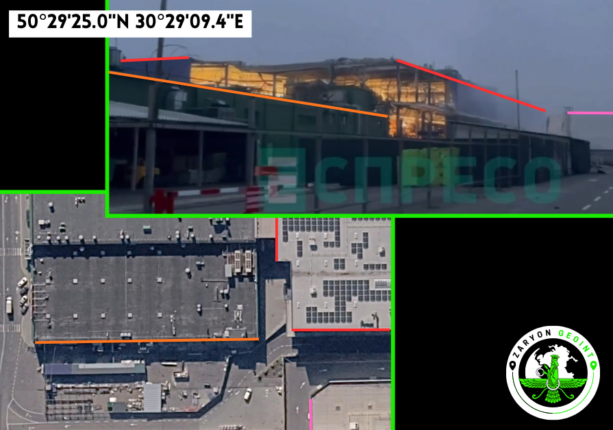
Damage to an "Epicentr" shopping center following a reported Russian ballistic missile attack.
50.490270, 30.485950
9G2GFFRP+49 Kyiv, Kyiv city, Ukraine
Vid2
Damage to a building of the Retail Park shopping complex following a reported Russian ballistic missile attack.
50.491030, 30.487170
9G2GFFRP+CV Kyiv, Kyiv city, Ukraine
GeoLocated by @zarGEOINT
Reported involved equipment:
Ballistic Missile (UNK-Type)
Geolocation:
xitter.cf/zarGEOINT/status/21131…
xitter.cf/Magyargeo56/status/211…
Location:
geoconfirmed.org/ukraine/f92…
Sources:
Vid1&2
xitter.cf/zarGEOINT/status/21131…
t.me/lachentyt/69227
Pic
xitter.cf/Zeldamices/status/2113…
t.me/uaobozrevatel/250624
Visit our map: geoconfirmed.org/map/ukraine

🇺🇦🇷🇺 A Russian strike hit Kyiv’s Epicentr shopping centre (video 1) and the neighbouring Retail Park shopping complex (video 2) overnight.
📍 Geolocation (video 1): 50.49027, 30.48595
📍 Geolocation (video 2): 50.49103, 30.48717
@GeoConfirmed @FaytuksNetwork @UAControlMap
1/2
Geolocation:
xitter.cf/zarGEOINT/status/21131…
➡️ Detailed geolocation:
🗺️ Kyiv [Київ], Kyiv Oblast, Ukraine
📍 Epicentr: 50.49027, 30.48595
📍 Retail Park: 50.49103, 30.48717
Links:
t.me/lachentyt/69227
t.me/insiderUKR/136771
2/2

Geolocation:
xitter.cf/Magyargeo56/status/211…

A Russian missile strike destroyed a JYSK store in the Pochaina area of Kyiv.
@GeoConfirmed @UAControlMap
📍50.491093, 30.486558

GeoConfirmed conflictmap UKR.
Damage to the residential complex "Atmosphere" (Lipetsk) following a reported Ukrainian drone attack.
52.612375, 39.585718
9G4XJH6P+W7 Lipetsk, Lipetsk Oblast, Russia
GeoLocated by @dmitrij46839
Geolocation:
xitter.cf/dmitrij46839/status/21…
Location:
geoconfirmed.org/ukraine/985…
Sources:
xitter.cf/Zeldamices/status/2113…
t.me/exilenova_plus/33156
More information
m.vk.ru/wall-104083518_77765…
Visit our map: geoconfirmed.org/map/ukraine


Geolocation:
xitter.cf/dmitrij46839/status/21…

A residential building strike in Lipetsk tonight.
geo: 52.612375, 39.585718
#GEOINT #OSINT
@UAControlMap @GeoConfirmed


GeoConfirmed conflictmap UKR.
Area grid - Reportedly, Russian cargo vessels ASCALON (IMO 9198226), LADY D (IMO 9349289), and ANASTASIIA (IMO 9349291) are loading significant quantities of military equipment at the Kaliningrad naval base, including logistics vehicles, infantry vehicles, MRAPs, and troop transports.
54.641200, 19.914200
9F6XJWR7+FM Baltiysk, Kaliningrad Oblast, Russia
GeoLocated by @InsiderGeo
Geolocation:
xitter.cf/InsiderGeo/status/2112…
Location:
geoconfirmed.org/ukraine/81f…
Sources:
xitter.cf/InsiderGeo/status/2112…
More information
xitter.cf/InsiderGeo/status/2112…
marinetraffic.com/en/ais/det…
marinetraffic.com/en/ais/det…
marinetraffic.com/en/ais/det…
Visit our map: geoconfirmed.org/map/ukraine

EXCLUSIVE: In a joint investigation by @InsiderGeo × @SONARROW_OSINT , we identified a large-scale Russian military loading operation in Baltiysk. Between October 15 and 16, we observed the Russian cargo vessels ASCALON (IMO 9198226), LADY D (IMO 9349289) and ANASTASIIA (IMO 9349291) loading significant quantities of military equipment at the Kaliningrad naval base, including logistics vehicles, infantry vehicles, MRAPs and troop transports.
A rotation of other cargo vessels also appears to have taken place in the days before and after, although heavy cloud cover over the period makes this difficult to confirm.
One or more large convoys are likely already underway. Their destination(s) remain unknown at this time.


More information
xitter.cf/InsiderGeo/status/2112…
All three cargo vessels have previously been linked to Russian military deliveries beyond Russian borders. In our investigation last month, ANASTASIIA was also tracked in Libya, further highlighting the role of these vessels in Russia’s military supply routes abroad. xitter.cf/InsiderGeo/status/2099…
GeoConfirmed conflictmap UKR.
Rough location of crash site - A Russian Su-30SM aircraft crashed in Kaliningrad Oblast.
54.655019, 21.898241
9G63MV4X+27 Timofeevka, Kaliningrad Oblast, Russia
GeoLocated by @99Dominik_
Reported involved equipment:
Su-30SM
Geolocation:
xitter.cf/99Dominik_/status/2112…
Location:
geoconfirmed.org/ukraine/a04…
Sources:
xitter.cf/99Dominik_/status/2112…
t.me/exilenova_plus/33122
Visit our map: geoconfirmed.org/map/ukraine

Geolocation:
xitter.cf/99Dominik_/status/2112…
A Russian Su-30SM aircraft crashed in Kaliningrad Oblast.
Rough location of the crash site - 54.655019, 21.898241
Timofeevka, Kaliningrad Oblast, Russia
@GeoConfirmed @UAControlMap @AndrewPerpetua


GeoConfirmed conflictmap UKR.
Point of view - A Russian Su-30SM aircraft crashed in Kaliningrad Oblast.
54.657372, 21.892981
9G63MV4V+W5 Timofeevka, Kaliningrad Oblast, Russia
GeoLocated by @99Dominik_
Reported involved equipment:
Su-30SM
Geolocation:
xitter.cf/99Dominik_/status/2112…
Location:
geoconfirmed.org/ukraine/126…
Sources:
xitter.cf/99Dominik_/status/2112…
t.me/exilenova_plus/33123
Visit our map: geoconfirmed.org/map/ukraine
Geolocation:
xitter.cf/99Dominik_/status/2112…
A Russian Su-30SM aircraft crashed in Kaliningrad Oblast.
Rough location of the crash site - 54.655019, 21.898241
Timofeevka, Kaliningrad Oblast, Russia
@GeoConfirmed @UAControlMap @AndrewPerpetua