Gainesville, FL
Joined July 2018
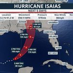
7:20 AM CDT Friday Oct 9 Update: Isaias becomes a major hurricane. Data from an Air Force Reserve hurricane hunter aircraft indicate that the maximum sustained winds have increased to 120 mph. Isaias is now a category 3 hurricane on the Saffir-Simpson Hurricane Wind Scale. Follow the latest at hurricanes.gov
23
483
68
1,072
195,210
Isaias has become the FIRST hurricane of the 2026 season. Landfall is still expected to occur near the westernmost Florida Panhandle late Friday night. Heavy rain & storm surge flooding, in addition to strong winds, are expected across parts of the Panhandle Fri into early Sat.
1
1
614
Megan Borowski retweeted
Living in the eastern and southeastern U.S. means being prepared for hurricane season and heavy rain events. If you have to evacuate, your car kit should be ready for flooding and power outages. Don't let a storm catch you off guard. Being prepared for flooding and storm-related hazards keeps you safe on the road. 🌀🌧️🚗 #HurricanePreparedness #CarEmergencyKit #NationalPreparednessMonth
4
45
4
129
35,120
Megan Borowski retweeted
Never Forget. Twenty-five years later, the National Weather Service joins the nation in remembering the 2,977 lives taken on September 11, 2001, and the families still carrying that day. We honor the victims. We honor the first responders who ran toward danger. We honor the courage shown in New York, at the Pentagon, and in the skies over Pennsylvania. To those who serve, protect, and keep watch every day: we stand with you.
19
260
4
1,137
41,347
Megan Borowski retweeted
Tropical Storm #Edouard has made landfall in Louisiana with max winds of 60 mph. The Atlantic has yet to have a #hurricane this year. Only 7 seasons in satellite era (since 1966) have gone into September without an Atlantic hurricane.
10
80
12
198
81,934
‼️ September is Florida Preparedness Month! As we enter the historic peak of hurricane season, now is the time to make sure you’re ready! Preparedness doesn’t stop once hurricane season begins—it’s a year-round commitment. 🌀 This #FLPrepMonth, we’ll be sharing simple, actionable steps to help Floridians prepare their homes, families, businesses & communities for whatever comes next. 💪 STAY ready so you don’t have to GET ready! Read more: ➡️ tinyurl.com/FLPrepMonth2026
1
20
2
29
3,802
🥵It's hot out there! Here are the 1:30 PM heat index ("feels like") values for our area. Make sure to stay hydrated, limit time outdoors and take breaks in the A/C.
2
5
1,016
Megan Borowski retweeted
Latest NMME shows a very classic El Niño winter setup, with above-normal precipitation across the South/Gulf Coast (including well above-normal in Florida) and cooler temperatures thanks to increased cloudiness. Across the Northern U.S. and Canada, the forecast is warmer and drier than usual. We'll definitely have to watch for severe weather across Florida this winter with the roaring subtropical jet. Some of Florida's worst non-TC tornados have come from El Niño winters, most notably 1997-1998.
10
55
9
344
83,466
Land breeze induced convection? @NWSTampaBay
5
106
Megan Borowski retweeted
Happy Fourth of July! 🇺🇸
2
135
4
639
6,805
🇺🇸 This Independence Day, @flsert urges Floridians to celebrate safely! Whether you're enjoying America’s 250th with fireworks, grilling by the pool, spending the day at the beach, or heading out on the water, a few simple precautions can help keep your holiday fun & safe. Follow the tips below & visit CPSC.gov/Fireworks to have a safe & happy Fourth of July! 🎆
8
31
4,033
🇺🇸Happy #IndepdendenceDay! 🇺🇸
Happy #IndependenceDay! Curious about what the weather was like in #Philadelphia when the Declaration of Independence was ratified? Well, according to observations kept by Thomas Jefferson, the afternoon temperature got to 76 °.
58
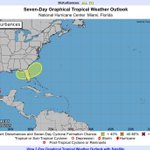
👀Low chance for *tropical* system... but an increase in rain chances is a GOOD thing. Nearly 80% of Florida remains in a drought. #FLwx
We'll be watching the Atlantic Coast for potential tropical development early next week. While the chance for a *tropical* system developing is low, we'll likely see an increase in rain chances and an increased risk for rip currents/beach hazards along the Atlantic next week.
2
331
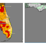
New drought monitor is out, & there's been improvement. Worst areas are slowly eroding away. More storms this week + potential for heavier rain next week in the Panhandle/N. FL should help further. (📷:left = latest monitor, right = change since last week. Green = improvement!)
52
Megan Borowski retweeted
🥵Summertime heat & humidity develops later this week into the weekend. ⚠️ Heat Index values are forecast to soar to the 104-108 degree range Saturday afternoon. 🌧️ Widely scattered showers/storms for north-central FL expected through mid-week increase area-wide into the weekend.
2
1
6
757
Megan Borowski retweeted
A widespread heat wave will build across the central U.S. through midweek before shifting to the East Coast, where it peaks on Friday, then slowly ease over the weekend. An early season heatwave can often be more dangerous and pose a greater risk for heat-related illness. This will be the most significant heat so far this summer for many locations. The most important things you can do in significant heat are to stay hydrated and interrupt your exposure to the heat by taking breaks out of the sun and/or being in cooled locations. Visit weather.gov for the latest forecast.
5
57
4
161
21,775
🌀 Early outlooks for the 2026 Atlantic Hurricane Season are already starting to circulate. Do you know how these seasonal predictions are actually developed? ➡️ Watch below to learn the science, data, & tools used to forecast the future before storms even form.
6
1
15
1,924
Megan Borowski retweeted
5/28: GOES-E shows that Saharan dust is reaching the eastern Caribbean Sea. Saharan Air Layer activity usually ramps up in mid-June, peaks from late June to mid-August and begins to rapidly subside after mid-August.
28
3
56
4,403
Megan Borowski retweeted
U.S. Drought Monitor May 28, 2026 For the 50 states and Puerto Rico, the U.S. Drought Monitor shows 50.77% in moderate drought or worse, compared to 52.15% last week. #DroughtMonitor #Drought #Drought2026
2
9
4
840
Megan Borowski retweeted
An El Niño will likely arrive later in the year, according to sea level data from Sentinel-6 Michael Freilich. The satellite—which measures the height of the entire ocean every 10 days—captured a swell of warm water hundreds of miles wide in the Pacific Ocean off the coast of South America.
48
471
49
1,260
107,576