

Amateur forecaster | providing updates on UK severe weather, Flooding and Atlantic tropical activity | Feel free to message me any questions!☀️🌦️⛈️
United Kingdom
Joined October 2016
- Tweets36.6K
- Following846
- Followers4.6K
- Likes67K




Pinned Tweet
My December Stats📈
Temperature🌡️
- Max Temp: 14.4°c
- Min Temp: -1.2°c
Rainfall🌧️
- Total: 74.8mm
- Average: 49.61mm
- Overall: 151% of average
————————————
2025 Brief Summary📈
Temperature🌡️
- Max Temp: 32°c (30th June)
- Min Temp: -5.8°c (9th January)
Rainfall🌧️
- Total rainfall: 594.4mm
- Average Rainfall (Jan - Dec): 582.2mm
- Overall 102% of average
After such a dry Spring & Summer the year ended with average rainfall overall☔️


Weather Updates retweeted

High pressure moves to our SE on Sunday paving way for a period of more unsettled conditions from the Atlantic.
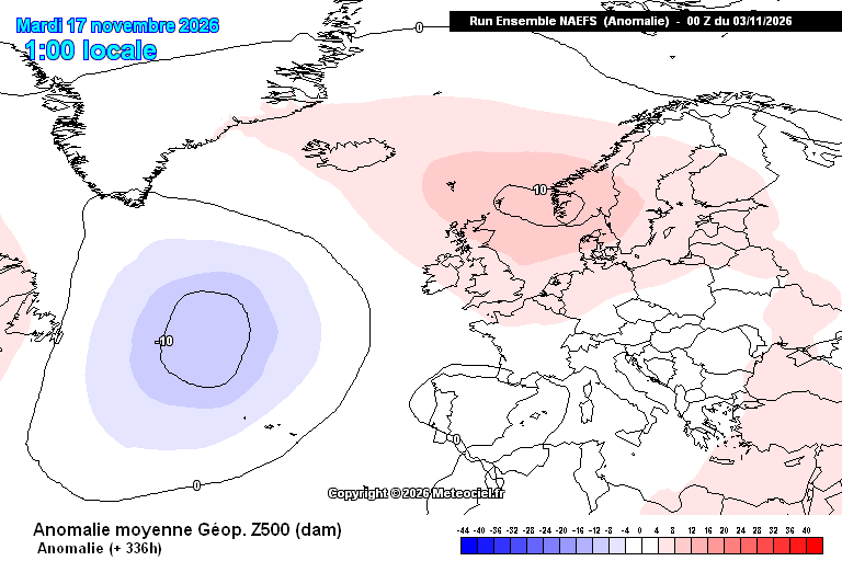
Quite a spread in outcomes, potentially very mild in the southern half of UK between 16th-18th all depending on positioning and angle of approach of the lows. Perhaps a risk of another named storm?
Going into the last week of November and into December, fair bit of uncertainty in the exact evolution, but there are some signs of some blocking to our north in the extended range.


Weather Updates retweeted

More than 30 vehicles have been involved in a crash on the M20 tonight; fog has been incredibly thick along some roads here in Kent this evening. One road was shut near Monkton in East Kent due to extremely poor visibility (barely to the car in front, probably <20 metres).

Two people have been seriously injured in a major motorway collision involving more than 30 vehicles on the M20 in Kent, forcing police to close both carriageways overnight
Updates at uknip.co.uk/news/uk/uk-news/… @uknip247
@SussexTW
Weather Updates retweeted

Still a lot of spread to the forecast model scenarios for how Tue-Wed's rainfall plays out in southern Wales & England.
Examples shown here are arranged from most to least aggressive with the north-eastward advance of wet weather.


Weather Updates retweeted

The switch to unsettled weather across the UK/NW Europe early next week can be traced to what’s happening in the Pacific in the next few days.
A developing low pushing into the jet stream causes a jet streak, this generates a Rossby wave that transfers eastwards across the planet.
The jet stream becomes more amplified across America and by the time the Rossby wave train arrives into the Atlantic, it powers up the jet stream and steers low pressure systems towards the UK.
This, helped along by the developing tropical forcing in the east Indian Ocean.


Weather Updates retweeted

⚠️ Yellow weather warning issued ⚠️
Fog across parts of England and Wales
Sunday 18:00 – Monday 11:00
Latest info 👉 bit.ly/WxWarning
Stay #WeatherAware⚠️
Weather Updates retweeted
Wow.
As the MJO becomes increasingly strong across the Indian Ocean and high pressure smashes into the East Asian mountains, this is going to trigger a huge surge in positive AAM tendency over the next 1-2 weeks.
With the MJO likely to continue transitioning east into phases 3-4 as November progresses, a substantial re-configuration of global weather patterns seems likely.
For the UK, the emergence of the MJO coupled with the recent fall in AAM is likely to lead to stormy conditions through the middle of this month, potential for another named storm or two? Before that zonal influence gradually weakens into the last week or so of November.
15th-22nd - Stormy conditions most likely
22nd-28th - Potential for further unsettled weather but becoming weaker in nature
Into December, with the likely major SSW & unknown impacts from that, this rising AAM and eastward MJO progression becomes increasingly favourable to high latitude blocking, any SSW downwelling will only support this outcome.
Early December potentially blocked and could bring the first proper cold spell of this season.
The generated Rossby waves from this huge AAM surge, largely driven by a strong +EAMT event could potentially lead to further disruption to the vortex, the idea of a quick recovery through the rest of November and into December is to me, looking increasingly iffy.


Weather Updates retweeted
⚠️ Yellow weather warning issued ⚠️
Thick fog across parts of southeast England
Friday 2100 – Saturday 1100
Latest info 👉 bit.ly/WxWarning
Stay #WeatherAware⚠️



Weather Updates retweeted
A dry and cloudy evening for many but there's the chance of some light rain in places and the odd heavier shower in southern coastal regions 🌧️
Feeling a little chilly, especially where skies clear, with some mist and fog developing 🌁
Weather Updates retweeted
It's a soggy Friday morning for some of us with an area of rain, locally heavy, currently moving northwestwards across the Midlands and Wales🌧️
Take extra care on the roads on your journeys this morning.
Weather Updates retweeted

A week of deluge followed by a week without rain.
Sums up recent trends - all or nothing!
River flows also swinging surprisingly fast too.


Weather Updates retweeted
Forecast modelling is currently faced with a 'fork in the road' situation for the middle of next week in the Atlantic-Europe sector.
Timing of movement of several lows determines whether an Atlantic ridge stays well to the northwest or moves toward NW Europe next Thu-Fri.

Weather Updates retweeted
Something unusual is happening high above the Arctic.
Find out more in the latest Deep Dive with Aidan McGivern
youtube.com/watch?v=YRGIGVSe…

Weather Updates retweeted

November
Plenty high pressure, more unsettled late on
High pressure to 9th, maybe something a touch unsettled 10-13th before more high pressure, particularly in the South
More widely unsettled possible late on, small chance of colder air, especially in North
#UKweather #LakeDistrict


Weather Updates retweeted
ECMWF's ensemble indicates a broadly a drier north, wetter south pattern to European rainfall for the next fortnight.
Could be a very wet period for Portugal & parts of western Spain, providing some relief for the drought-affected areas.


Weather Updates retweeted
The MJO looks to be on the move east through the first half of this month at a relatively strong amplitude.
This, combined with a likely +EAMT event gives me doubt over a rapid stratospheric vortex recovery.
In any case, further disruption seems plausible during the second half of November.
Late November / early December continues to look interesting from a blocked and potentially cold point of view across NW Europe.


Weather Updates retweeted
A couple days later and we now have a historically weak polar vortex. It looks to stay historically weak into middle of November before making a rebound and strengthen. Although the extent of this re-strengthening is difficult to predict.


We are getting to the time of year when the stratospheric polar vortex (SPV) starts to attract the attention of weather enthusiasts, but this year that interest is building a little earlier than usual, and for good reason.
Models are increasingly signalling an exceptionally strong weakening of the SPV for the time of year, with some ensemble members even forecasting a reversal of the zonal-mean winds from westerly to easterly. If the winds reverse before 28th November, it would set a new earliest date for a major sudden stratospheric warming (SSW) in the records dating back to 1959.
As for the impacts? It is still far too early to suggest this will translate into an increased risk of cold and wintry weather across the UK going into late November and December. The timing is crucial, and at this stage of autumn, the stratosphere has plenty of time to evolve before any potential impacts reach the troposphere.
Had this been happening 3 weeks down the line, we might have had a little more reason to get excited about the prospects for winter, but for now, this is just one to watch on how it evolves.

Weather Updates retweeted
Hello 😊
I’ve just pushed out a new update for my app CloudCast and I’ve also extended the beta testing from 50 users up to 250, so many more can now download it!
- 4 more charts are available
- Redesigned Tides & Journey cards
- Over 25,000 towns added, so your location should be more accurate
- New solar / northern lights forecast
Along with a host of bug fixes and subtle improvements.
Thanks to everyone for the bug reports & feedback, it’s massively helping to improve this app.
testflight.apple.com/join/4R…


Weather Updates retweeted
Another foggy night is expected for parts of England and Wales in particular
Take extra time and care if travelling into Sunday morning 👀
Weather Updates retweeted
We’ll be releasing the full October 2026 statistics on Mon 2 Nov
But early provisional Met Office statistics show that October has seen:
- Above average UK temperatures
- Above average UK rainfall
- Above average UK sunshine
There is much regional variation in these figures, and we’ll explain all on Monday
