

Associate Professor of Meteorology at Purdue University. Husband, father, and storm chaser. Nondenominational Christian. Insufferable centrist. Opinions my own.
West Lafayette, IN
Joined February 2012
- Tweets7.5K
- Following655
- Followers1.3K
- Likes15.7K






Daniel T. Dawson II retweeted

One other point about Milton - at *no* point was it forecast or expected to make landfall as a category 5 hurricane in Florida.
Even when it *was* a category 5 hurricane near the Yucatan, its peak wind speeds were expected to decrease due to wind shear from a nearby trough.

Daniel T. Dawson II retweeted

830pm EDT Oct 9th: Doppler radar data indicates that the eye of #Hurricane #Milton has made landfall near Siesta Key in Sarasota County on the west coast of Florida.
Max sustained winds at landfall are estimated at 120 mph.
Landfall TCU: nhc.noaa.gov/text/refresh/MI…


Daniel T. Dawson II retweeted

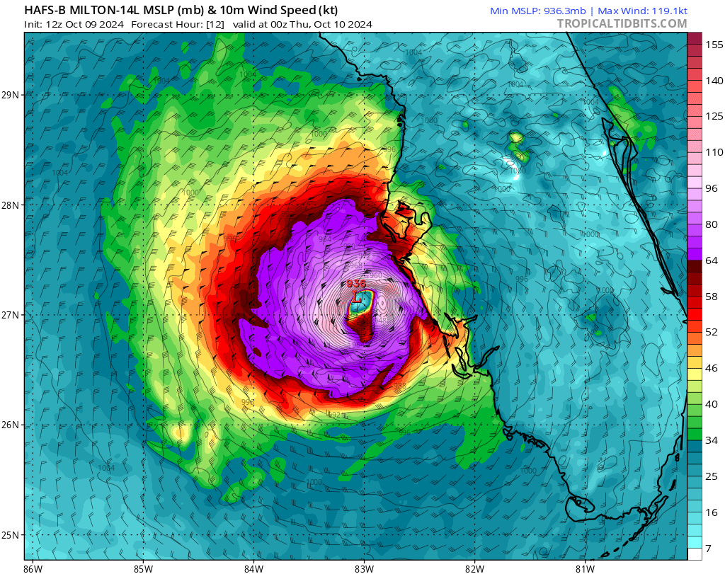
Hurricane models have advertised an area of strong winds developing on the backside of #Milton (likely due to interaction with the jet) and I think we might be seeing evidence of that on the Tampa radar now. Watch to see if this picks up in recon and radar data this evening. – at Homestead, FL

Daniel T. Dawson II retweeted

1-minute #GOESEast Infrared images showed Hurricane #Milton as it remained at Category 5 intensity during the past 5 hours. GLM-detected #lightning activity persisted within the inner eyewall of Milton.
Daniel T. Dawson II retweeted

Beautiful tribute from @NOAA_HurrHunter who earlier this evening honored longtime radar scientist and researcher Peter Dodge who passed away in March 2023.
His ashes were dropped in the eye of Category 5 Milton tonight –
PETER DODGE HX SCI (1950-2023) 387TH PENNY

Daniel T. Dawson II retweeted
One way to visualize Hurricane Milton's evolution is through hovmollers - averaging wind around different radii bins and comparing their evolution with time.
I annotated Milton's recon-derived hovmoller to show notable features of its complex evolution over the last 2 days:


Daniel T. Dawson II retweeted

#Hurricane #Milton has reintensified to a Category 5 hurricane with max winds of 165 mph. Milton is the strongest Atlantic hurricane this late in the calendar year since Wilma (2005).
Daniel T. Dawson II retweeted

For God's sakes, don't tell me to "do research" on weather. I'm a meteorologist. My literal job is to research the weather.
Daniel T. Dawson II retweeted

Pardon my Appalachian hoots and hollers but this is right up there with the Ian flight from two years ago. Floor panels came up. Dropsondes broke. A mess in the cabin.
All that turbulence and we still get the dropsonde out to collect data. This is the job. Important work.

Bumpy ride into Hurricane #Milton on @NOAA WP-3D Orion #NOAA43 "Miss Piggy" to collect data to help improve the forecast and support hurricane research.
Visit hurricanes.gov for the latest forecasts and advisories
Visit noaa.gov/milton for information that you can use before, during, and after the storm
There's a new version of this post
Daniel T. Dawson II retweeted
#Milton's pressure has fallen to 897 hPa - the lowest pressure in an Atlantic #hurricane since Wilma in 2005 (882 hPa).
Daniel T. Dawson II retweeted
10:55 CDT Monday Update: Milton rapidly intensifies into a category 5 hurricane. Data from a @53rdWRS hurricane hunter aircraft indicate that the maximum sustained winds have increased to 160 mph (250 km/h) with higher gusts. Follow the latest at hurricanes.gov


Daniel T. Dawson II retweeted
If people, including elected public officials, are telling you that we can control the weather, they are wrong. Rhetoric like that is unhelpful at best, and dangerous at worst.
From someone who routinely flies into hurricanes, I assure you that we cannot control the weather.


Daniel T. Dawson II retweeted

To address rumors - the NOAA WP-3D Orion N42RF #NOAA42 and crew are in good condition and have completed their mission. During their second of four eyewall passes in Hurricane #Helene, the crew orbited within the eye to release a second uncrewed aircraft system for research purposes. The crew was also evaluating if landing conditions would allow a return to home base instead of point of origin. Thank you for your concern, "Kermit" and crew are fine. #FlyNOAA #research #aviation
Daniel T. Dawson II retweeted
With a lot of focus on Helene's unusual inland impacts, I thought I'd delve a bit into the meteorology of what makes this such an unusual hurricane long past landfall.
Currently, Helene is being quickly steered northward between a ridge to the east & cutoff low to its northwest:
Daniel T. Dawson II retweeted

It's still going...
Every Tampa Bay area tidal gauge has set an all-time record high level so far tonight
Clearwater, FL has smashed its previous record by more than 2 feet. High tide still coming in. #Helene

Daniel T. Dawson II retweeted
Join us in the flight station to see what it's like flying into a hurricane!
This morning @NOAA WP-3D Orion #NOAA43 "Miss Piggy" flew a critical mission into Hurricane #Helene ahead of its landfall later today. Data collected will help improve intensity forecasts and support hurricane research.
Check @NHC_Atlantic and hurricanes.gov for the latest forecasts and advisories. #FlyNOAA